Access Control – 472
Access Control (472) is defined by the NRCS as the temporary or permanent exclusion of animals, people, vehicles, and/or equipment from an area.79 The practice applies on all land uses and is used to achieve or maintain desired resource conditions in an area.79 Controlling access to an area can help prevent use-related damage and degradation, dust generation from vehicular traffic, and excessive removal of vegetative cover by livestock or human activities.80 Access control might be for an entire management unit or for a specific area needing protection within a larger unit.81
Access to an area can be managed through the installation of constructed barriers such as gates and fences, planting vegetative barriers of trees or shrubs (refer to the Conservation Practice Standard (CPS) Hedgerow Planting (422) when using this approach), electronic or sonic devices, signage, patrols, or some combination of these.82-84 Physical barriers may be constructed from conventional fencing materials or from natural materials such as logs, boulders, or earth-fill.82-84 Barriers should be adequate to accomplish the intended exclusion or limitation of use by target populations and should not pose a safety hazard.80 To prevent accidents, any physical barriers that cross roads should be clearly marked with bright reflective paint, signs, or other reflective material.80,84 Barriers should also not impede emergency preparedness and response activities such as those for fire control – for example fire suppression crews may have need to access pumper truck water sources on or near the area.79
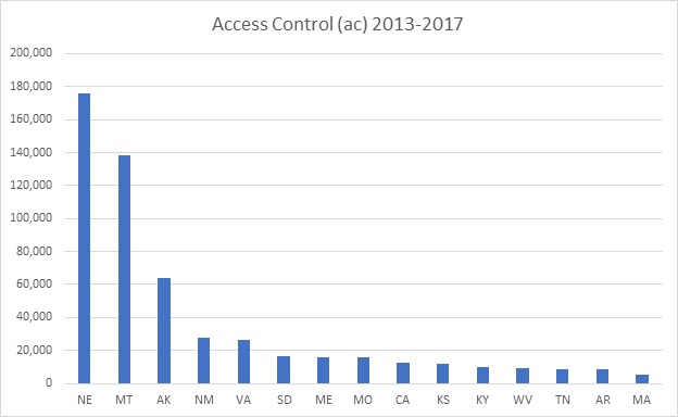
When planning to install access control structures, consideration should be given to the impact on non-target species such as local wildlife, and on cultural resources (e.g., soil compaction from fence installation).85 The operator must also comply with applicable federal, state, and local laws and regulations during the installation, operation, and maintenance of this practice.80 Potential landowner and user liability should be assessed before installing barriers to control access.85 Figure 7-3 shows the top 15 states implementing Access Control during 2013-2017.

Anionic Polyacrylamide (PAM) Erosion Control – 450
Anionic Polyacrylamide (PAM) is a synthetic water-soluble soil additive used to increase flocculation of soil particles, improve water infiltration, and temporarily stabilize the soil surface to reduce wind and water erosion.
Application of PAM for Erosion Control (450) applies to:
• irrigated lands susceptible to irrigation-induced erosion where the sodium adsorption ratio (SAR) of irrigation water is less than 15;
• critical areas where the timely establishment of vegetation may not be feasible, or where vegetative cover is absent or inadequate;
• areas where plant residues are inadequate to protect the soil surface from wind or water erosion;
• sites where disturbance activities prevent establishment or maintenance of a cover crop.
This practice does not apply to soils with peat or organic matter surface horizons, nor does it apply to the application of PAM to flowing waters that are not being used for irrigation.86
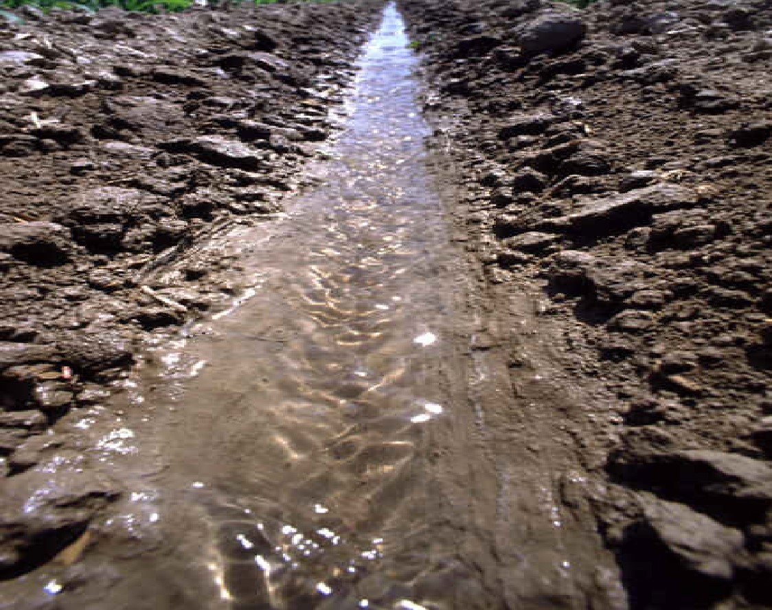
PAM works by binding soil particles together and increasing soil stability through enhanced aggregation.88 Application of PAM can reduce dust emissions and improve water quality.89 It can also improve soil surface infiltration rate and minimize soil surface crusting, which aids plant growth. Although it can be very helpful in the short term, PAM loses effect relatively quickly and may need reapplication within 6-8 weeks, and potentially sooner in highly exposed areas.90 For this reason, PAM should be considered a temporary solution to be used in combination with other erosion-control measures. For example, seed can be combined with the PAM mixture to provide longer-term erosion control.86,90,91 PAM applied to the soil surface and then covered with a layer of mulch may remain effective for several months.92
The anionic form of PAM, provided it is free of nonylphenol (NP) and nonylphenol ethoxylates (NPE) which are often used as surfactants,86 is non-toxic and environmentally benign when used in the recommended amounts.88 Cationic PAM, on the other hand, is extremely toxic to fish and aquatic life and should never be used.88,91 Anionic PAM used for Anionic Polyacrylamide (PAM) Erosion Control must meet acrylamide monomer limits of ≤ 0.05 percent, have a charge density of 10 to 55 percent by weight, and have a molecular weight of 6 to 24 mg/mole.86 PAM can increase downstream or offsite sediment deposition if it mixes with sediment-laden waters downstream of the application site,86 as it will cause flocculation of the suspended sediments which then fall out of suspension.
PAM comes in emulsion, granular, and brick or log form.90 PAM requires turbulent mixing with water to fully dissolve the product.93 Beyond that, it does not require specialized application equipment and can be applied through regular irrigation equipment, hydromulcher, water truck, or similar means. Some special handling may be required to avoid clogging the nozzles of sprinkler systems.86 Mechanically incorporating PAM into the soil reduces, rather than increases, effectiveness. If an area is disturbed after application, then PAM will usually need to be re-applied.90,91 Thus, PAM is usually not a consideration, particularly for wind erosion control, in cropping systems that utilize intensive tillage. PAM is not effective when applied over snow-cover.91
The correct application rate of PAM depends on the soil properties, slope, and the resource concern being addressed.86,91 Specifications developed uniquely for the site should be prepared for each unit being treated.94 PAM works best on fine and medium-textured soils; it typically will reduce, rather than increase, infiltration on coarse-textured soils.86 PAM is an excellent alternative for controlling irrigation erosion where erosive surface irrigation streams are used to optimize irrigation efficiency, where tailwater recovery systems are used, and/or on graded furrow irrigation systems where concentrated flow may cause erosion. Using more than the recommended amount of PAM will not increase effectiveness86 and may clog soil pore spaces, decreasing infiltration.92 The maximum application rate for critical areas is 200 pounds per acre, per year, of pure form polyacrylamide.86 To be effective, PAM needs a source of divalent cations, such as Ca+2 or Mg+2.95 In many arid climates, Ca+2 and Mg+2 are already naturally present abundantly within the soil, however soil testing can determine this. A supplemental source of divalent cations, if needed, can be applied to the soil (i.e., gypsum) or mixed with the PAM solution at the time of application.95 Idaho NRCS has published a number of help sheets that give directions for finding the reports in Web Soil Survey32 that contain soil and site properties of interest when planning various NRCS conservation practices, including PAM Erosion Control. These help sheets are included in Appendix B, Exhibit 7-1.
PAM does not store well, so it is generally not recommended to bulk-purchase more than will be needed at a given time.96 PAM must be mixed and applied in accordance with Occupational Safety and Health Administration (OSHA) Material Safety Data Sheet requirements and the manufacturer’s recommendations.96 Safe handling requires the use of proper personal protective equipment (e.g., gloves, masks, and other health and safety precautions) in accordance with the label, industry, and other Federal, State, and local chemigation rules and guidelines.96 Inhaled dry PAM can cause choking and difficulty breathing.86 The operator is responsible for complying with all Federal, state, and local laws, rules, or regulations, including those governing land-applied additives and surface water discharges.91 PAM solution can make surfaces extremely slippery, so care should be taken not to spread or spill PAM on roads or other paved surfaces.86,91
PAM Erosion Control is not a widely used practice across the nation and no nationwide statistics for use of this practice were available to the authors at the time of creating this handbook.
Brush Management – 314 and Herbaceous Weed Treatment – 315
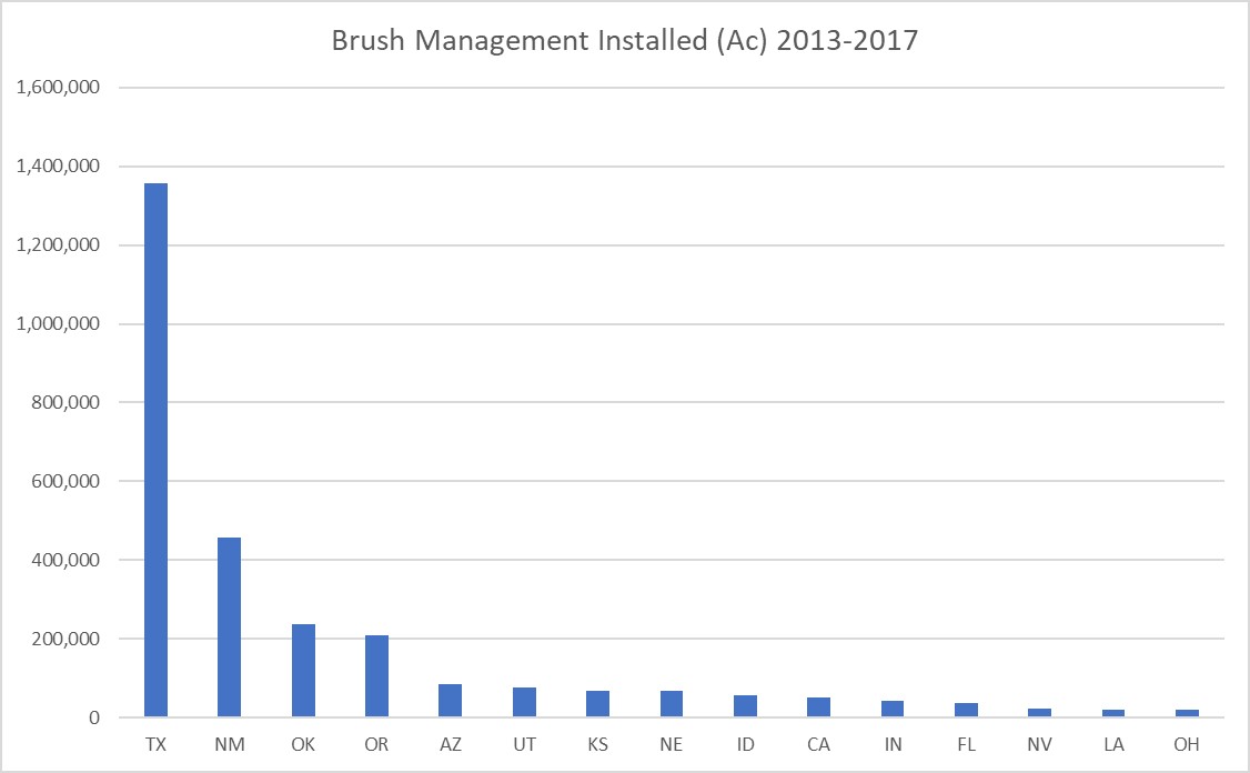
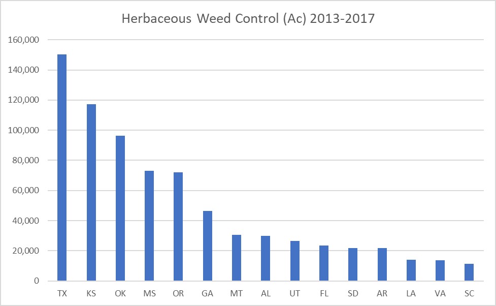
Brush Management (314) and Herbaceous Weed Treatment (315) both pertain to the removal of one or more undesirable vegetation species on a non-cropland area. Unwanted vegetation can be removed using mechanical, chemical, burning, or biological methods, alone or in combination. Brush Management applies to the management or removal of woody (non-herbaceous or succulent) plants including those that are invasive and noxious,97 while Herbaceous Weed Treatment pertains to the removal of unwanted herbaceous species, including those that are invasive, noxious, or prohibited.98 The requirements and considerations for Brush Management and Herbaceous Weed Treatment are very similar. The standards for both practices also suggest using Integrated Pest Management (595) in support of brush or herbaceous weed control efforts. When burning is chosen as a brush or weed removal method, then CPS Prescribed Burning (338) also applies (see section on Prescribed Burning).97,98
As specified by the NRCS Practice Standards, Brush Management applies on all lands except active cropland where the removal, reduction, or manipulation of woody (non-herbaceous or succulent) plants is desired. Herbaceous Weed Treatment applies on all lands except cultivated cropland and horticultural cropland, including orchards and vineyards, where removal, reduction, or manipulation of herbaceous vegetation is desired. These practices do not apply to removal of woody or herbaceous vegetation by prescribed fire (Prescribed Burning) or removal of woody or herbaceous vegetation to facilitate a land-use change (CPS Land Clearing (460)).97,98
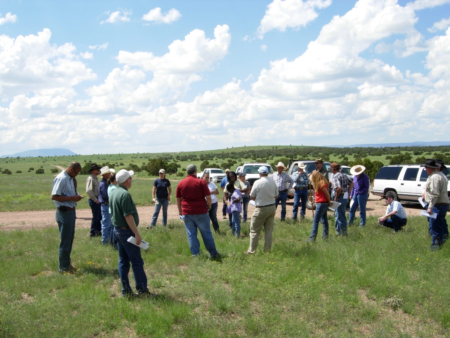
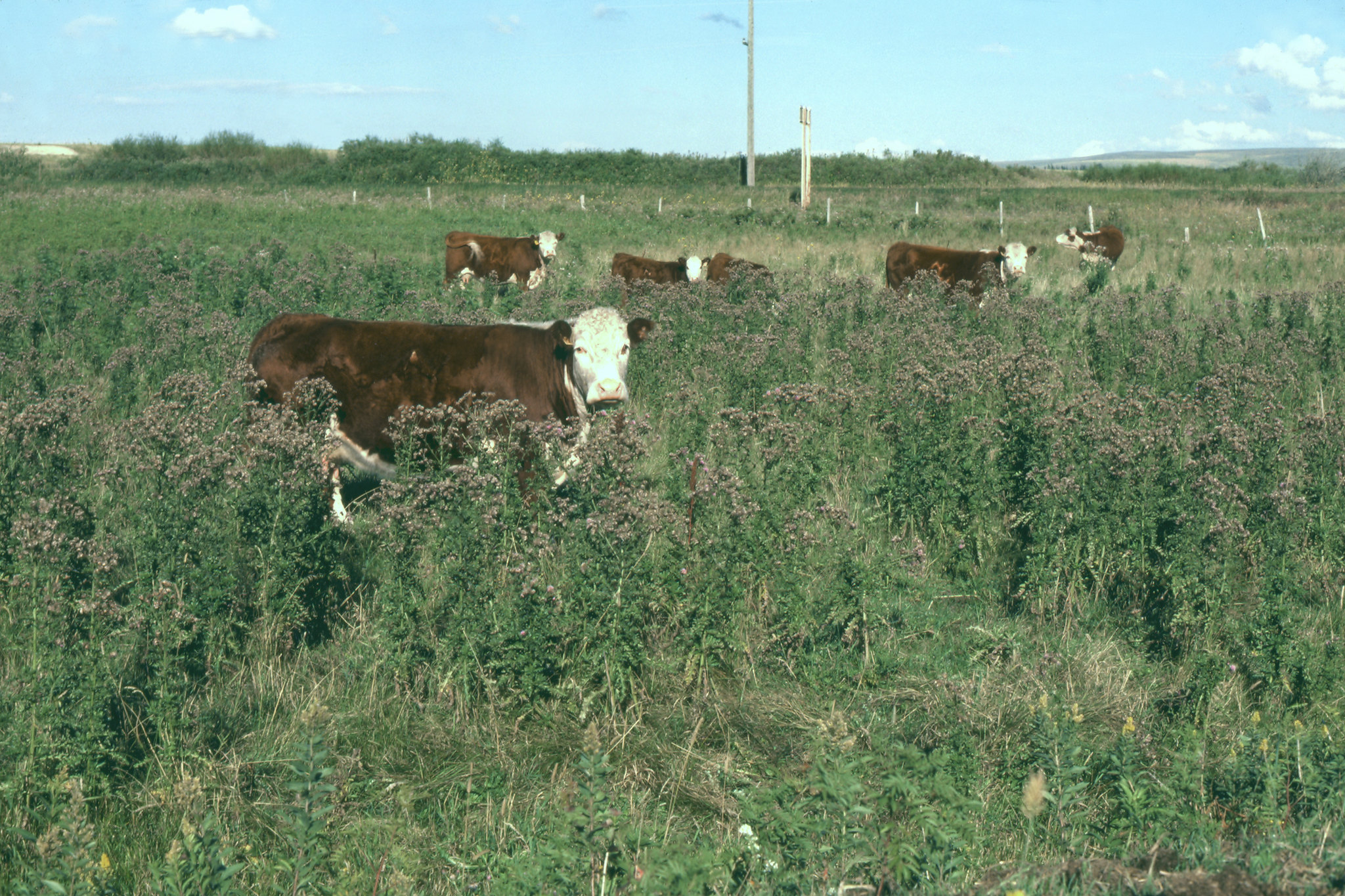
Woody brush in densities sufficient to compete with herbaceous species can reduce the herbaceous ground cover, potentially leaving bare or sparsely vegetated areas which are susceptible to increased wind erosion. Reducing brush can help allow for the restoration of a more desirable plant community that provides improved habitat for wildlife, improved forage, and better erosion control.99 Sometimes the remaining desirable plants at a site lack the vigor or abundance necessary to provide an adequate seed supply or otherwise re-populate the area naturally.100 It may be that the brush encroachment has already eliminated most or all of the preferred understory vegetation species at the site.100 In these instances, the desired vegetation will not come back on its own, and the area will need to be seeded to achieve the desired outcome.100 Range Planting (550) or Forage and Biomass Planting (512) are recommended follow-up practices where natural revegetation with desired species is unlikely.97 In areas of low rainfall, however, Range Planting has a low chance of success, so the decision to use this approach must be made judiciously within the context of local site and climatic conditions.100 Removing brush or weeds when there is little likelihood of the area revegetating with a more desirable species in a reasonable amount of time may only make wind erosion problems worse by removing what little cover currently exists. Where Brush Management/Herbaceous Weed Treatment and any needed follow-up practices are advisable, a period of grazing deferment to allow for desirable plant establishment is usually needed following the brush/weed removal. Length of the grazing deferment may be as short as “until the end of the growing season”101 or as long as one to two years,102 depending on local variation in standard requirements; the needed deferment period may be longer in the presence of other complicating factors such as drought.102 It is not uncommon to need to repeat brush or weed removal over the two to three years following the initial treatment to manage vegetative regrowth or seedling emergence from built-up seed stocks of the undesirable species in the soil.100
Developing a plan for brush or weed removal will in almost all cases be done in such a way as to move vegetation cover and composition toward the reference plant community described in the Ecological Site Description103 (ESD) for that area.100 Managing for a plant community not typically found under natural conditions can be disruptive to the ecosystem.100 If the reference plant community includes, for instance, 30% cover by a woody species targeted for removal, then a removal density which supports this composition would normally be selected.100 Instructions for how to find ESD information in the NRCS Web Soil Survey can be found in Appendix B, Exhibit 7-1. An exception to this general guidance would be in the case of naturalized pasture, which is historically forested land that is deliberately being kept in herbaceous vegetation and managed for pasture.100 On naturalized pasture, woody plant removal is often conducted as a maintenance to prevent the site from reverting back to its natural wooded state.100,104 NRCS will usually only assist with the initial clearing of woody brush on such sites, with subsequent maintenance activities being the responsibility of the land owner or manager.100
The impact on wildlife should be taken into account when planning brush or weed removal.97 As a general rule of thumb, it is preferable to create a mosaic of irregular vegetation patches rather than block treatment of an area.98 However, when creating a plan that leaves some brush standing for wildlife use, the most beneficial pattern (see diagrams below) will depend on the target wildlife species.100 Ungulates, for example, will often benefit most from patterns that maximize edge effect – the increased diversity found at the interface between two habitat types.100 Birds may do well with a patchy pattern that leaves clumps of brush standing, while ground-dwelling wildlife may need corridors through which they can travel from one area of habitat to the next.100 The diagrams below and their accompanying explanations come from the National Range and Pasture Handbook, Chapter 8 - Wildlife Management on Grazing Lands,105 and serve to provide a few examples of different configurations that a land manager might want to consider when planning a brush removal pattern for their land. Which pattern is best will depend on the plant community characteristics and the target wildlife species.
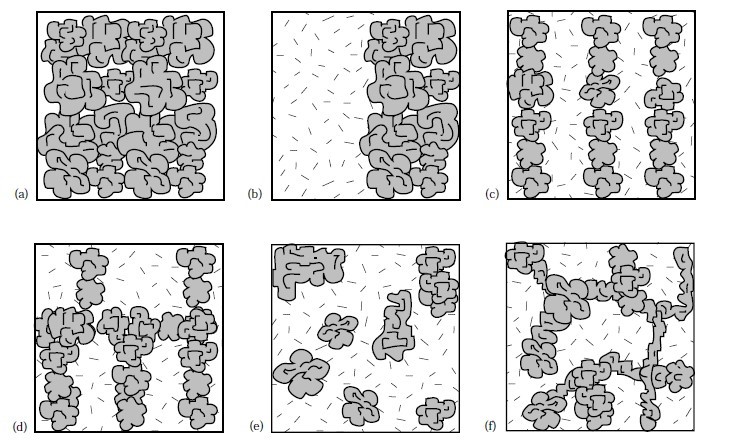
"A landowner wishes to apply brush management and range seeding on a rangeland pasture dominated by brush species. Many alternative designs can be considered in planning and implementing the practices. The five alternatives shown provide for half of the pasture (a) to be cleared and seeded and half to remain in brush.
• Alternative b is the simplest approach and provides for some edge between the grass and brush halves of the pasture.
• Alternative c provides six times the linear edge effect.
• Alternative d provides even more edge plus wildlife travel corridors between the brush strips.
• Alternative e provides a greater amount of edge and leaves brush motts that provide a natural appearance.
• Alternative f provides for the greatest amount of edge and interspersion of habitat types, a natural appearance, and wildlife travel corridors between brush motts."105
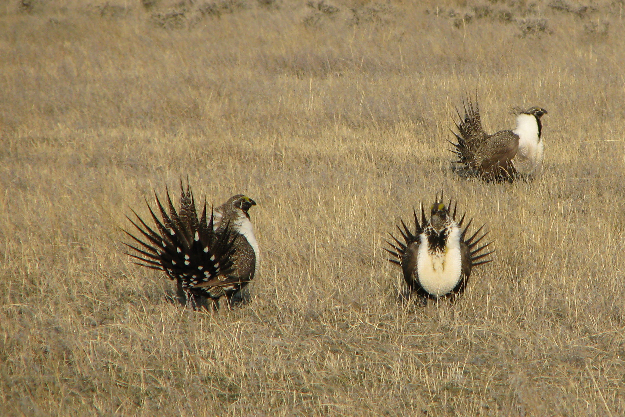
In areas where a species of special concern, such as the Greater Sage-Grouse, is known to exist and/or make use of the habitat type under consideration for treatment, there may be specific requirements that the local NRCS office can either advise on or suggest appropriate resources for.102
Despite the ultimately positive effects of brush removal, this practice does have the potential to temporarily increase the risk of erosion on the newly cleared area, particularly if mechanical methods which disturb the soil are used. When planning for brush control, it is important to consider methods and timing that will minimize soil disturbance and soil erosion.97 The various options for plant removal under Brush Management/Herbaceous Weed Treatment are briefly summarized below.
Mechanical control
There are many forms of mechanical control, including chaining/cabling, railing and dragging, mowing or rotobeating, grubbing, discing, root-plowing, manual pulling/cutting, girdling, shearing, mastication, bulldozing, and other similar methods.99,106 When selecting a control method, the target species needs to be considered, as not all methods are effective for all species. For example, alligator juniper (Juniperus deppeana), a species common in the Western US, will re-sprout from roots and stumps left in the ground by methods that only destroy the above-ground parts of the plant.100 Mesquite (Prosopis spp.), common to the Southwestern US, will also re-grow from root/crown and in addition has the potential to damage mastication equipment due to the hardness of its wood.100 Grubbing may be a more appropriate method for controlling species with characteristics such as these.100 Usually the local NRCS or Cooperative Extension office will have personnel with the expertise needed to identify the best removal method for a given locally-occurring species. Disposal of debris following a mechanical clearing may include things like shredding/chipping of large woody species, piling and burning, stacking and leaving piles of debris to serve as wildlife shelters, or leaving felled large woody species to decompose in place, where advisable.107,108 In some cases, leaving residue such as downed large woody species in place may provide conditions in which harmful pests can thrive,109 so care should be taken not use a method that will have unintended negative consequences.
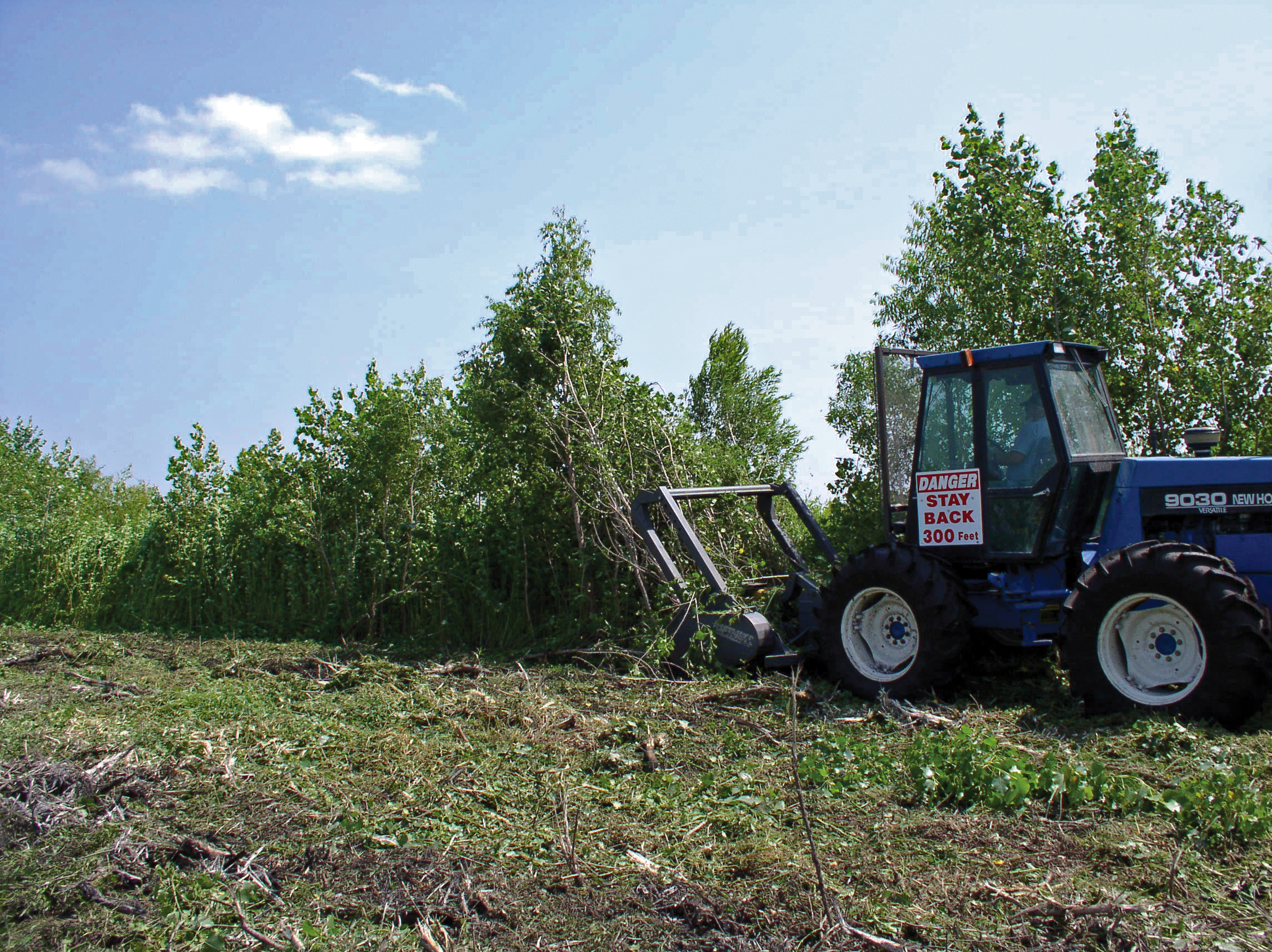
Mechanical treatment is generally considered a ground disturbing activity and may require a completed cultural resource assessment before proceeding.102,108,110 The difficulty of reseeding an area should also be given consideration before selecting a treatment which causes soil disturbance.107 Seasonal use of the area by local and migratory wildlife or pollinators for reproductive and other life cycles (i.e., nesting) may mean that the treatment will have to be planned to take place outside of the usual nesting/fawning/calving/etc. season for the species of concern.97,98
Chemical control
There are several options for applying herbicide, which include but are not limited to aerial broadcasting, ground-based sprayers, foliar spot-treatment, soil spot treatment, or painting stumps following mechanical removal. Methods which minimize chemical drift and excessive chemical application are encouraged.97,98 Consequences to non-target species should also be considered; for example, in situations where broad-scale application of an herbicide to treat an undesirable woody species will also kill desirable forbs that may be needed by wildlife or pollinators, a manually applied spot-treatment to just the target plants may be a better alternative.100 Herbicides vary by chemical in their effects on non-target species and specific considerations will depend upon which one is selected for treatment of an area.100 NRCS cannot make recommendations for chemical treatments but may be able to provide appropriate resources for this type of information.98,99 Cooperative Extension can provide recommendations on herbicide treatment, as can a qualified agricultural consultant.108 The most appropriate chemical, application rate, and application method will depend on the plant species and abundance, and may also need to account for other factors such as soil type (for example, high amounts of clay and soil organic matter can adsorb to some herbicides making them less effective111). Plant growth stage and timing of application can also affect how well the herbicide works.107 Proximity to organic agricultural operations may be a consideration for some operators.101 The operator should always read and follow label directions closely and comply with all State and Federal laws, with maintenance of Appropriate Material Safety Data Sheets (MSDS).97 MSDS and pesticide labels may be accessed on the Internet at: http://www.greenbook.net/. An evaluation and interpretation of herbicide risks associated with the selected treatment(s) using WIN-PST (an environmental risk screening tool for pesticides112) or other NRCS-approved tools is required for Brush Management and/or Herbaceous Weed Treatment.98,99
Biological control
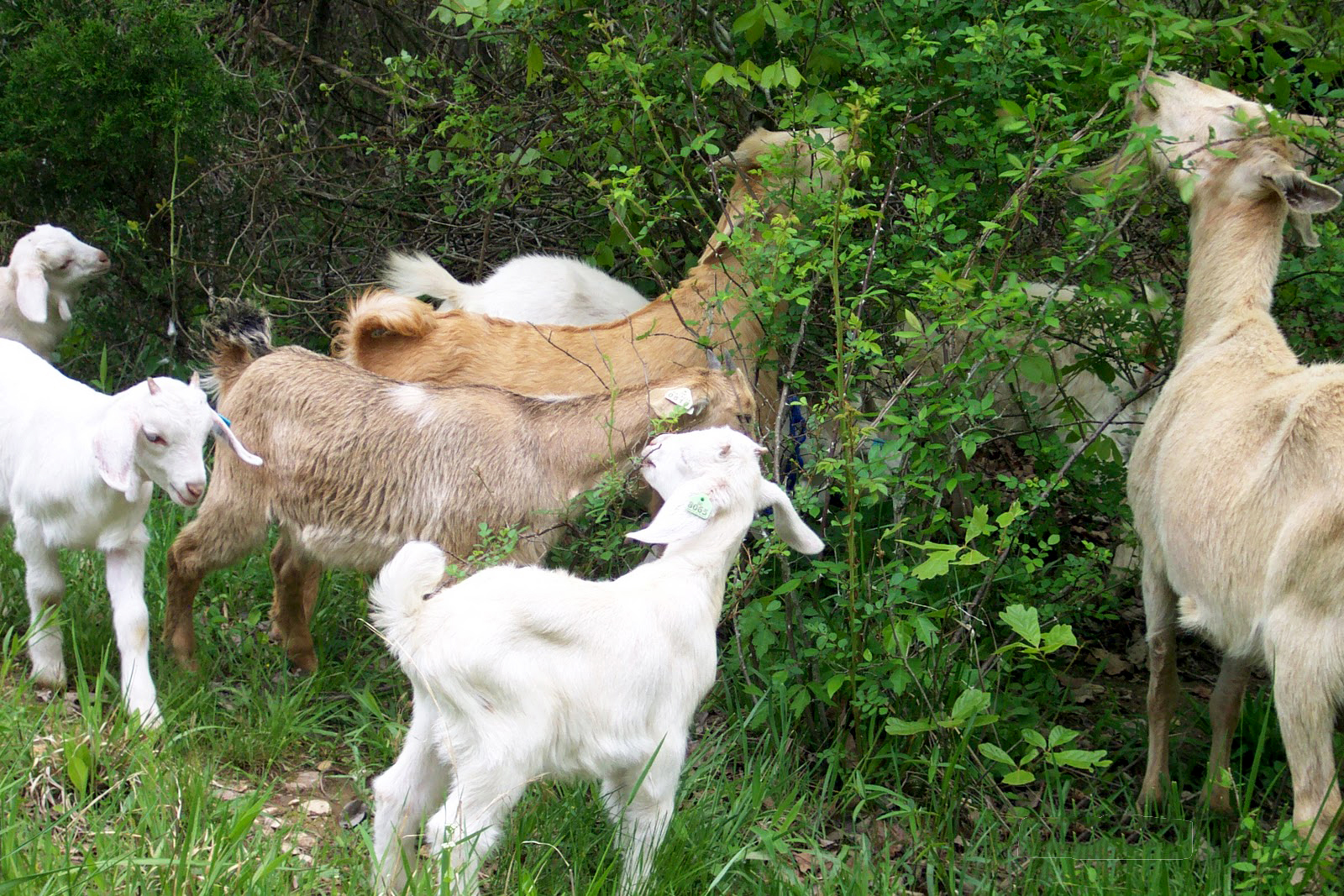
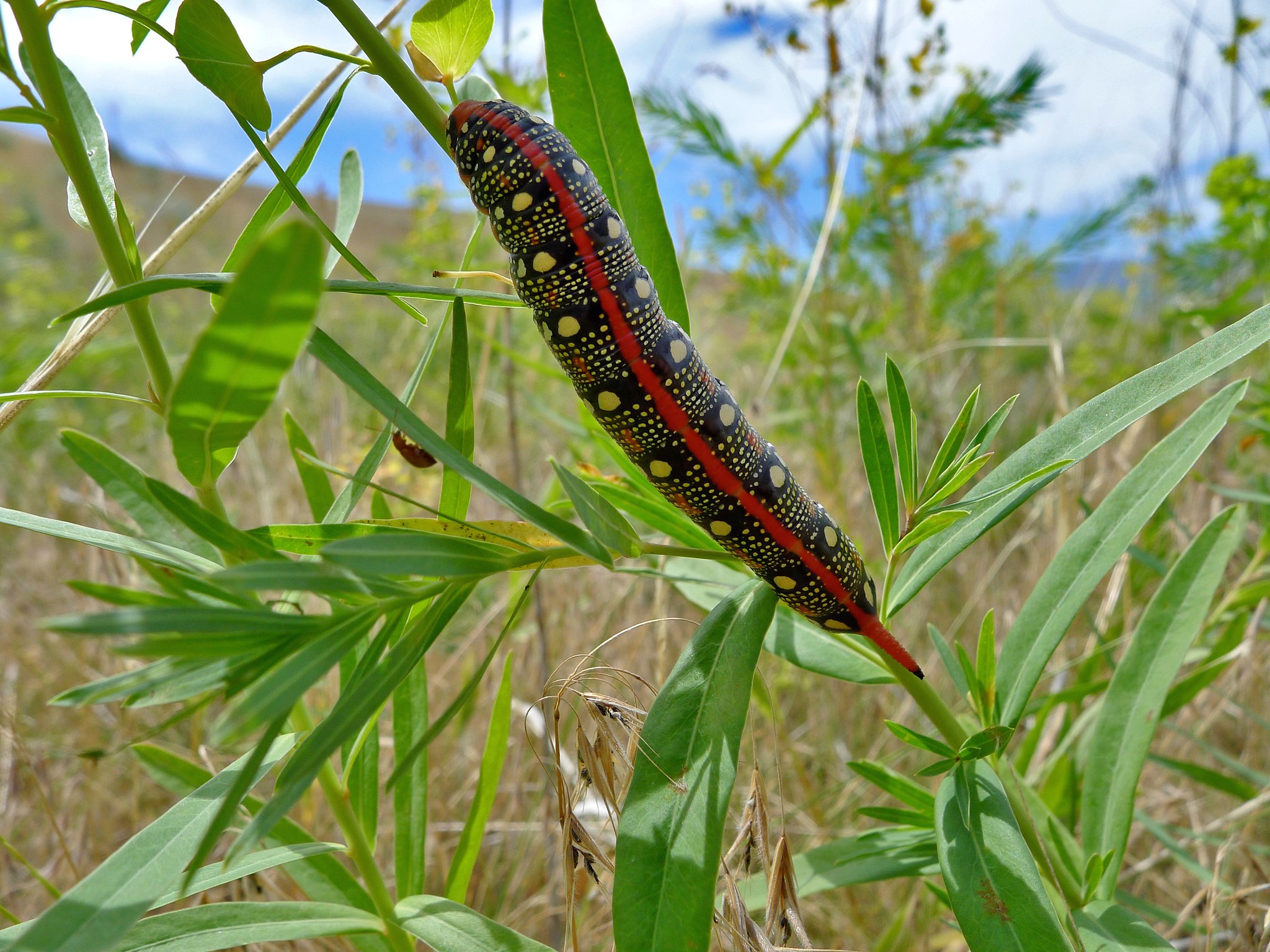
The most commonly applied type of biological control is targeted grazing, often with browsers such as sheep or goats. Use of grazing animals is the only form of biological control for which NRCS will develop recommendations, although they may be able to suggest appropriate alternative resources.98,99 When the NRCS does make grazing recommendations for biological control CPS, Prescribed Grazing (528) applies in conjunction with the CPS for Brush Management/Herbaceous Weed Treatment.98,99 Helpful resources may be also available from other sources such as land grant universities and Cooperative Extension. The University of Idaho offers a number of resources on Targeted Grazing113 including a Targeted Grazing Handbook114 online that contains information on the principles and practices of biological control through grazing. Other methods of biological control include the release of insects or diseases which target the undesirable plants. Cornell University hosts a webpage115 with information about biological control agents of insect, disease, and weed pests in North America.
Burning
Burning for brush or weed control should be carried out according to the CPS for Prescribed Burning, which is addressed under its own heading in this handbook.
The most effective control method(s) to implement for brush or weed management is highly dependent on the species of concern and the individual site characteristics. Often the local NRCS Field Office Technical Guide (FOTG)69 will either have detailed species-specific recommendations or direct the user to resources where such recommendations can be found. Cooperative Extension programs and their associated Land Grant Universities are also an excellent resource for this type of information and may also offer locally applicable publications or online decision tools to assist in determining an appropriate treatment method.
Critical Area Planting – 342
Critical Area Planting (342) as defined by the NRCS is the practice of establishing permanent vegetation on sites that have, or are expected to have, high erosion rates, and on sites that have physical, chemical, or biological conditions that prevent the establishment of vegetation with normal practices. The establishment of permanent vegetation serves to stabilize susceptible areas such as:
• sand dunes and riparian areas;
• stream and channel banks, ponds and other shorelines;
• constructed earthen features such as berms;
• highly disturbed areas such as active or abandoned mine sites and construction or urban restoration sites;
• areas affected by natural disasters such as wildfires, floods, hurricanes or tornados;
• other areas degraded by human or natural events that may be prone to high rates of soil erosion by wind or water.116
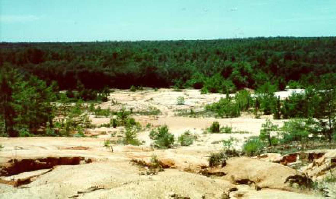
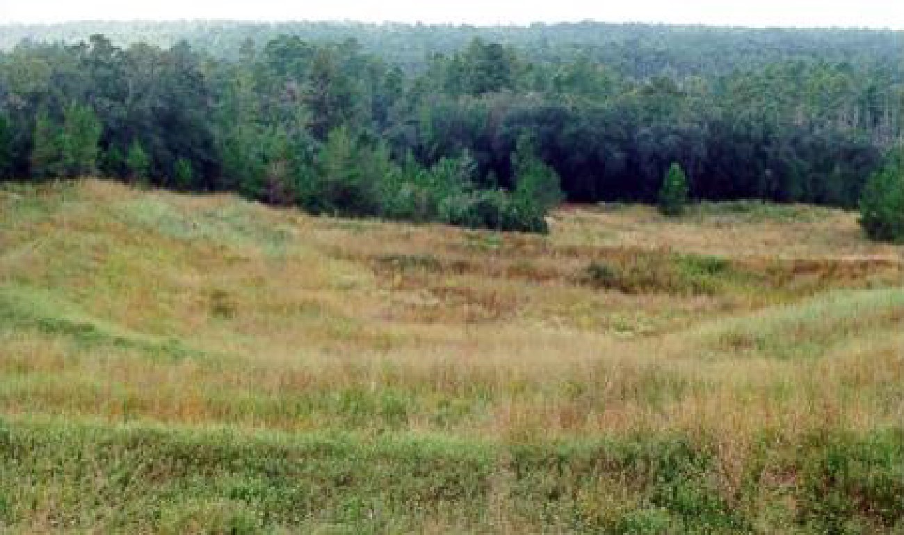
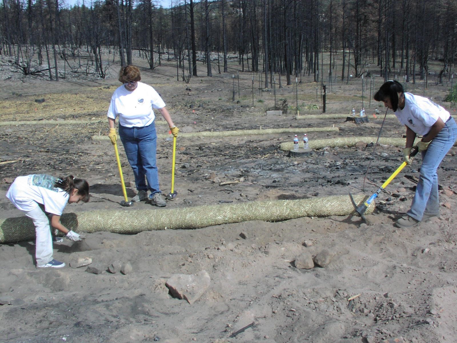
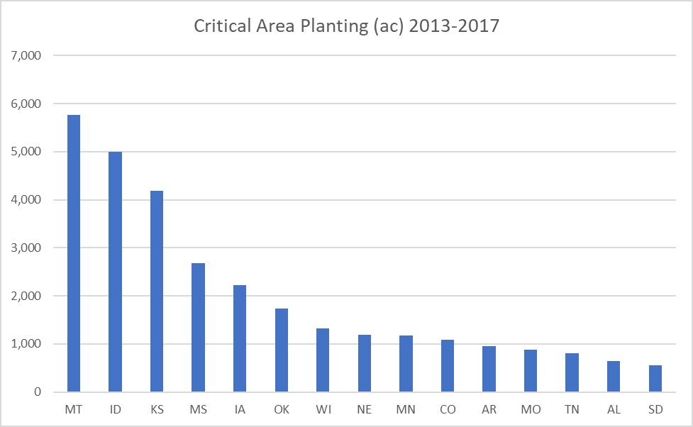
Critical Area Planting requires a site evaluation to identify any physical, chemical, or biological conditions that could affect the successful establishment of vegetation.116 Necessary site preparation may include mechanical leveling or shaping of the area, filling in deep gullies and cuts, and seed bed preparation.118 Depending on local soil conditions, addition of lime, fertilizer, or other amendments may also be needed.116 A soil test is often recommended, but not always required. The local NRCS FOTG should be consulted for details on the Critical Area Planting requirements specific to state and conservation site type. Mulching (484) is typically indicated as a component of Critical Area Planting in order to facilitate vegetation establishment. Hydromulching is routinely considered, as it offers the ability to apply seed, mulch, tackifier, and fertilizer in one operation. Grazing access to the site must usually be suspended during vegetation establishment, and in some cases permanently, depending on the erodibility of the area.118,119 The site should also be protected from pests and wildlife damage during establishment, and potentially for maintenance as well; however, care should be taken to minimize harmful impacts to wildlife particularly with regard to maintenance practices.118,119
The specifics of the site will determine what additional steps may need to be included in the conservation plan. For instance, in areas where a suitable growth medium for vegetation establishment does not exist at the soil surface, topsoil may need to be brought in and distributed across the site.120-122 Topsoil, where present prior to mechanical site modification, can be removed and stockpiled for later use but should not be stored any longer than necessary and for no more than two years.121,122 For sites that are currently being affected detrimentally by water erosion, the flow route of the water may need to be diverted before proceeding.101 Sites with active dunes and blowout areas present a unique challenge and are generally best addressed by being treated in stages, by stabilizing the upwind contributing area(s) first before addressing the areas associated with deposition accumulation, so that newly planted vegetation on these areas does not immediately become buried by sediment before it can establish.101
The vegetation selected for planting a critical area should be locally appropriate, compatible with existing vegetation in the area, and adapted to the conditions found at the site.116 The selected species should have the capacity to achieve the density and vigor needed to stabilize the site within an appropriate period of time.116 Planning tools such as the WEPS, Water Erosion Prediction Project (WEPP), RUSLE2, Rangeland Hydrology and Erosion Model (RHEM), or also the Aeolian Erosion (AERO) Model anticipated for release in 2020 (see Aeolian Erosion (AERO) Model in Chapter 3 of this handbook), may be used to determine the amount of established vegetation cover needed to reduce soil erosion to a level that is within management objectives. Reports available from the NRCS Web Soil Survey can supply soil erodibility factors and other soil information helpful for planning purposes; available reports of particular relevance to the concerns stated in the practice standard are noted in this help sheet from Idaho NRCS, also included as part of Appendix B, Exhibit 7-1. Other site conditions to consider in selecting appropriate vegetation species include soil chemical and physical properties, climate, slope, and exposure. For example, vegetation used to stabilize sand dunes should be able to tolerate being buried by blowing sand, sand blasting, drought, heat, and low nutrient supply.116
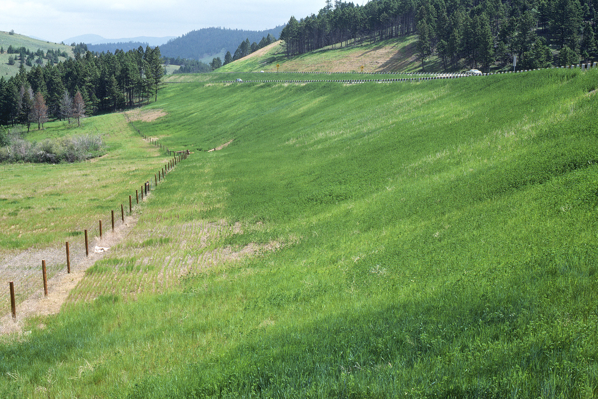
A list of approved plants for this practice that are considered appropriate for erosion control in a given state is usually available from the NRCS and should be followed. The CPS for Critical Area Planting usually requires the use of certified seed where available, and no species that are listed on Federal, state, or other locally applicable (e.g., tribal) noxious weeds lists may be used.118,121-123 Use of native species, where appropriate to the site conditions, is usually preferred. Inclusion of a small quantity of one or more flowering species with strong roots to benefit pollinators is also suggested as a consideration. Since the perennials used to establish permanent vegetation may be slower growing, a faster-growing annual may also need to be planted to provide temporary cover to immediately stabilize the area of concern.117,124 In some cases, the permanent vegetation can be seeded through the cover crop residue using a no-till or conservation tillage technique; this maximizes protection from wind erosion and eliminates the need for mulching.124 Guidance on establishing temporary cover or on the use of a nurse crop, however, varies substantially by state, and the local NRCS FOTG should be consulted for details on recommended species as well as when and if this practice is appropriate in a given area. Likewise, appropriate planting dates and methods are best obtained from the local NRCS field office or technical guide. All plans and specifications for each field or management unit should be prepared according to the Criteria and Operation and Maintenance sections of the Critical Area Planting CPS for the state of interest.
Dust Control on Unpaved Roads and Surfaces – 373
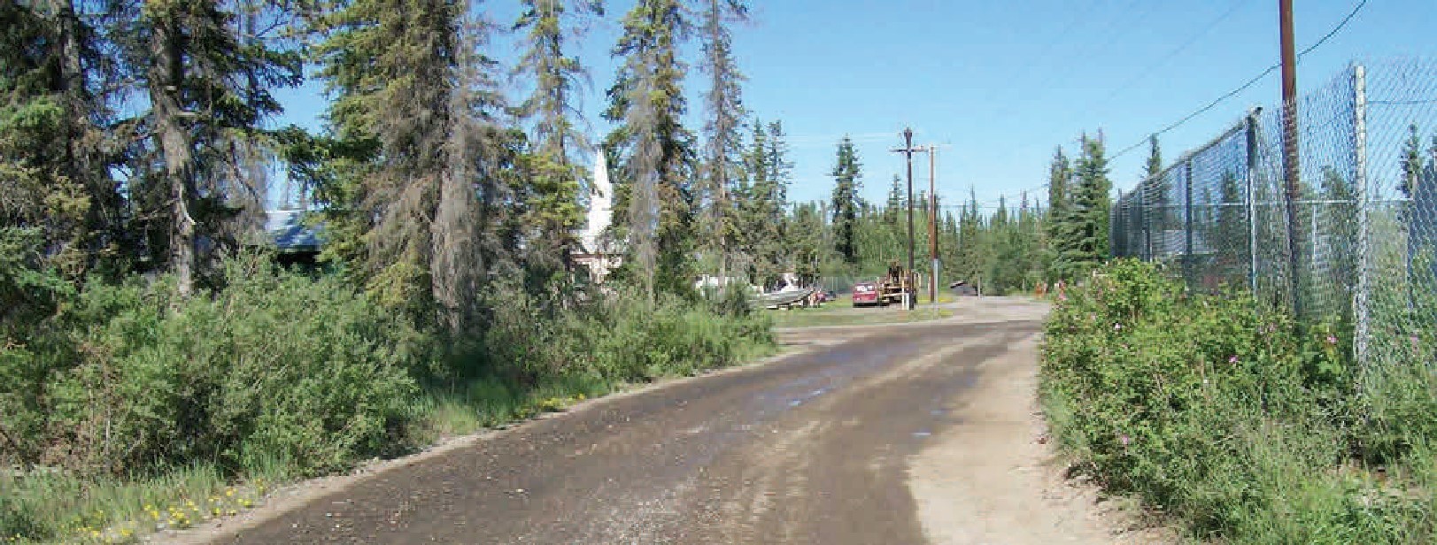
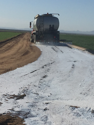
Dust Control on Unpaved Roads and Surfaces (373) consists of applying a dust-suppressing palliative product on unpaved surfaces where vehicle movement or wind action would normally occur. Examples of areas where this conservation practice applies are unpaved roads and parking lots, staging areas, and equipment storage areas. This practice does not apply to rangeland, cropland, vegetated areas, or areas subject to animal activity such as corrals. An assortment of dust-controlling products exists. Acceptable palliative products for use under the CPS for Dust Control on Unpaved Roads and Surfaces are: water; water absorbing suppressant (hygroscopic palliative); adhesive; petroleum emulsion; polymer emulsion; clay additive; and bituminous (petroleum-based road oil).125
The type of product chosen will depend on factors such as the length of time that dust suppression is needed, traffic intensity, vehicle types, local climate, and proximity to water bodies. The USDA Forest Service has produced a Dust Palliative Selection and Application Guide126 which contains information about a range of palliatives, including application tips, typical application rates and frequency, product limitations, and environmental impacts. Currently, this is the only USDA publication available to assist in selecting the proper dust control product, and this industry has continued to advance over the last 20 years. Other state and local units of government have released more recent publications that include newer products that have become available, such as the U.S. Department of Transportation, Federal Highway Administration's Unpaved Road Dust Management, A Successful Practitioner's Handbook.127 It is important to select a product that is suitable for the area of concern; for example, calcium chloride and magnesium chloride are both hygroscopic/deliquescent palliatives and require a certain amount of atmospheric moisture to work,126 so they should not be used in areas where the daily summertime relative humidity averages below 30%.125 Lignosulfonate, an organic non-petroleum product, should not be used in areas where the runoff could enter fish spawning waters.128 Some products may require restricting access to the area after application to allow the product to cure – liquid asphalt, for instance, may need 7-10 days to cure before resuming normal traffic.129 Roads and other surfaces may need to be graded or smoothed in preparation for applying a palliative; refer to the selected product’s guidance materials for appropriate site preparation.128
Where practical, also consider using measures such as speed control, vehicle exclusion, establishment of vegetation, windbreaks, and/or mulching to support dust control on unpaved areas.131 Where there is concern about an applied palliative entering local water bodies through runoff, it may be helpful to install buffer strips along the sides of the road or unpaved area to minimize transport.131
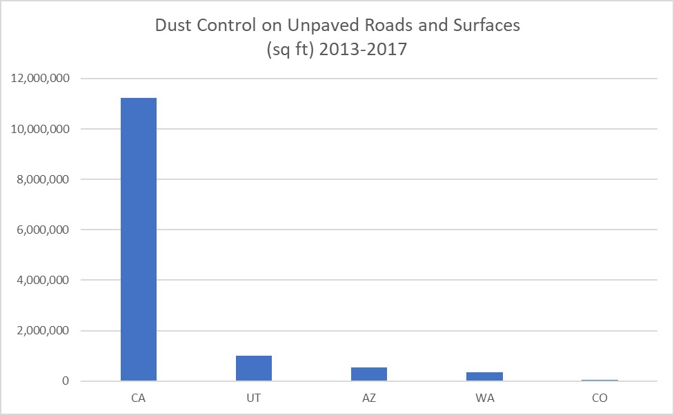
During the 2013-2017 evaluation period, only five states implemented the NRCS practice Dust Control on Unpaved Roads and Surfaces. As shown in Figure 7-21, the practice was implemented much more widely in California than in other states.
Forage and Biomass Planting – 512 and Range Planting – 550
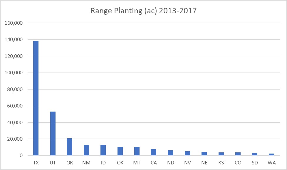
Range Planting (550) and Forage and Biomass Planting (512) are two practices designed to improve vegetative cover and reduce erosion on grazing lands. Both practices call for the establishment of suitable plant species adapted to the site. The practice standards have similar requirements and considerations. However, Range Planting is restricted to native and naturalized plant materials that are consistent with the ecological site description for the area being treated. Whereas, Forage and Biomass Planting can include any species, varieties, and cultivars suitable for pasture, hay or biomass production. Another difference is Range Planting can include grasses, forbs, shrubs or trees and Forage and Biomass Planting is restricted to herbaceous plant materials.
Range Planting is an intervention conservation practice utilized when the current vegetation is degraded to a point that natural reseeding will not occur and grazing management will not likely recover the site. Range Planting is a restoration practice and normally not considered a routine practice. The seed mix consists of native species to the area, as per the ecological site description. The ecological site name can be obtained from Web Soil Survey on the internet, and then cross-referenced to state’s FOTG Section II for a complete description of the ecological site. Since range planting consists of native species, the seed mix can be expensive. The conservation planner must develop a seed mix that is economical, has a noted success rate, and consists of seed varieties that are readily available and adapted to the site. Oftentimes, compromises must be made. Most state’s FOTG will have a seed/vegetation guide that lists which species are adapted to the Major Land Resource Area (MLRA), Common Resource Area (CRA) and/or Ecological Site. Some guides will give specific recommendations on seeding rates, depth of planting, and when to plant. However, until the planner develops the expertise to make recommendations on his/her own, it is best to consult a plant materials specialist or ecologist.
The risk of an unsuccessful range planting is greater as average annual rainfall diminishes and evapotranspiration increases. For instance, in the arid southwest, range planting is rarely attempted in areas with less than 10” precipitation and a hyperthermic temperature regime. An exception to that rule would be in large, wide, flat watershed drainages that receive moisture from runoff, or in areas of man-made topographic improvements designed to re-route and/or collect runoff. Considering climate change and increased temperatures and increased variability of precipitation, evaluating site suitability for range planting should be closely examined.
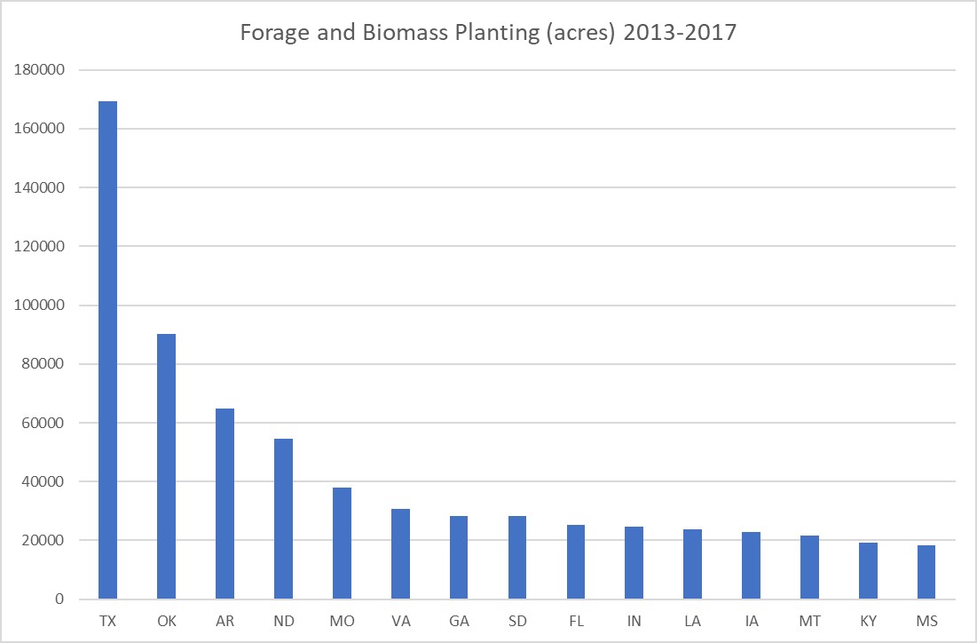
Forage and Biomass Planting, on the other hand, may have the benefit of irrigation as an option to establish and support the planted vegetation, such as on irrigated pasture and hayland. If irrigation is not going to be applied, then similar considerations as mentioned above for Rangeland Planting will apply to planting forage in areas of low precipitation; the chances of plant survival and success should be carefully evaluated before beginning. This is particularly true if existing vegetation or ground cover will be removed in the process of site preparation and planting. Although plants established under Forage and Biomass Planting are not limited to native species,132-134 as is the case in Rangeland Planting, it is still important to select species which are adapted to the region, site conditions, and intended use. Many state FOTGs have plant recommendations or criteria for selecting species appropriate for the area and purpose, as well as locally relevant guidelines for successful planting and establishment. Some relevant soil and site properties that can be obtained from Web Soil Survey are listed in Appendix B, Exhibit 7-1. Consider using site preparation and planting methods that will minimize particulate emission, such as no-till, to protect air quality.135 For effective wind erosion control, plants should be able to produce good ground cover and have enough root mass to stabilize the soil.132
For both Range Planting and Forage and Biomass Planting, appropriate management is needed to sustain the benefits achieved from the treatment. If the area is to be grazed, following a Prescribed Grazing plan can aid in maintaining the forage in a desirable condition.136
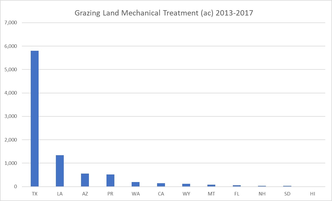
Grazing Land Mechanical Treatment – 548
Grazing Land Mechanical Treatment (548) as defined by the NRCS refers to modifying physical soil and/or plant conditions with mechanical tools by treatments such as pitting, contour furrowing and chiseling, ripping or subsoiling, and aeration or plugging.137–139 It is usually performed as a treatment to correct conditions such as excessive water runoff from an area, compacted soil with poor permeability, or root-bound conditions and thatch which needs to be broken up.137 The treatment helps by increasing water infiltration and reducing runoff, increasing plant vigor, and in some cases reducing competition from undesirable plants.139 Like brush and weed removal, Grazing Land Mechanical Treatment does not directly reduce wind erosion but can positively influence plant production and yield,139 which in turn increases ground cover and root networks. This helps to hold the soil in place and lessens the potential for wind erosion.
Grazing Land Mechanical Treatment can be used on pastureland, rangeland, grazed forest, and native pastures, but is only suitable where the slopes are less than 30 percent and where disturbance will not result in unacceptably high soil erosion.137 Commonly associated practices include Range Planting (550), Forage and Biomass Planting (512), Herbaceous Weed Treatment (315), Prescribed Grazing (528), Integrated Pest Management (595), and Nutrient Management (590).137,140 Grazing land mechanical treatment should only be done in areas that are relatively free of noxious or undesirable plants, as these may increase after surface disturbance.137 Prescribed Grazing is a requirement following Grazing Land Mechanical Treatment and is considered essential to the success and long-term maintenance of this practice.137 The treated area will in most cases need to be rested from grazing for a time following the treatment. Length and timing of requisite grazing deferment varies and is usually specified in the local NRCS FOTG, but in general is one to two years and takes into account the reproductive cycle of the desirable vegetation.140–142
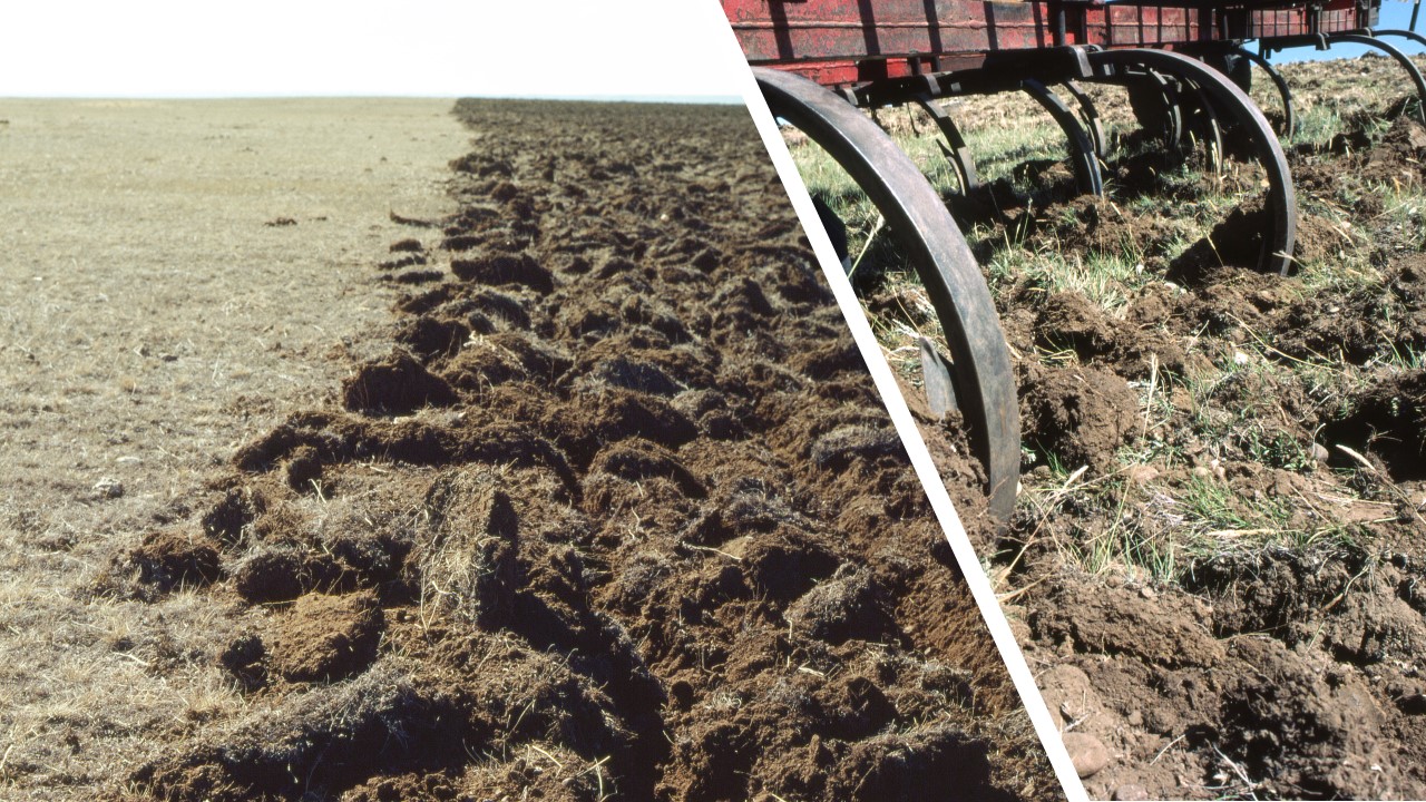
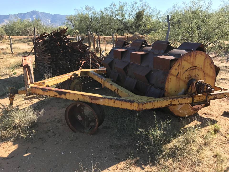
Mechanical treatment should take place when the soil is dry enough that the equipment will not cause compaction, yet still contains enough moisture to facilitate adequate penetration and disturbance of the compacted soil layers.138,142 Fine textured soils that are too dry may clod excessively.138 In general, tillage for this practice should be applied when soil moisture is no more than 30% of field capacity.140,142,143 When ripping to break up compacted soil layers that restrict root growth and limit water infiltration, the depth of compacted layers should be investigated with a probe or other suitable tool prior to ripping to determine the appropriate treatment depth.137,138
This practice is not suitable for all soil types and all areas.138,141,142 Suitable soil textures, percent slope limits, and other site considerations for a given treatment type (e.g., chiseling) are usually described in the locally applicable FOTG. Depending on the level of expected soil disturbance, the maximum acceptable slope may be less than the 30 percent limit specified in the general practice description.138,142 The ability of livestock to navigate the terrain following treatment should also be considered,137 as increased surface roughness may hinder usability.
Mechanical treatment which disturbs the soil below depths that have been disturbed by previous activities can potentially pose a risk to buried cultural resources that may exist in the area; therefore it may be necessary to consult with a cultural resource specialist when preparing the plan for this practice.137,141 One should also be aware of any buried pipelines, tile drains, or other buried structures which need to be avoided so as not to cause damage the equipment or to the structure.137,142
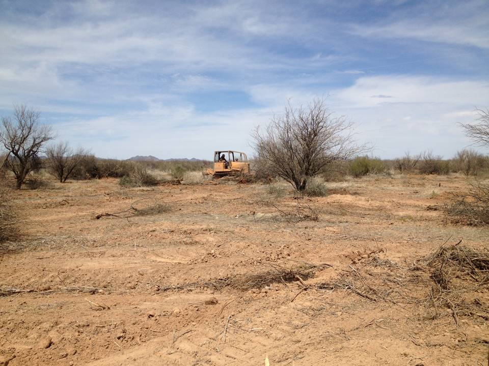
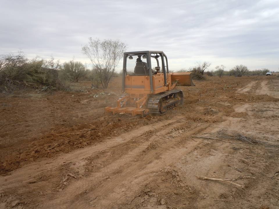
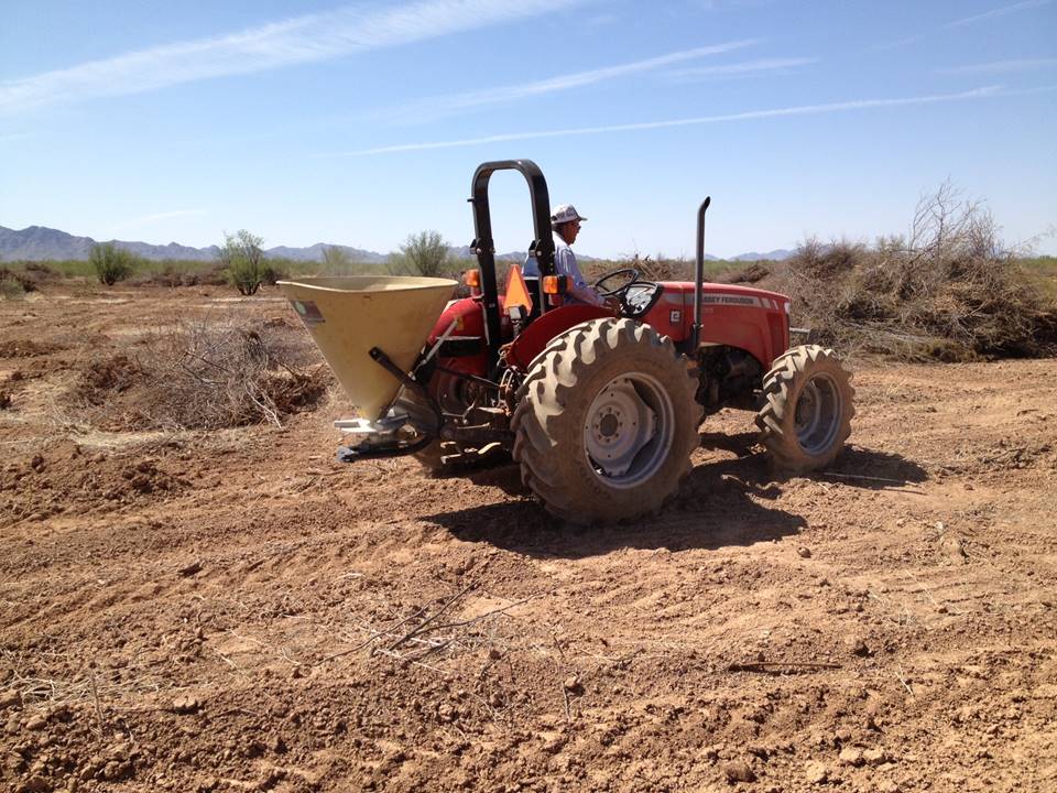
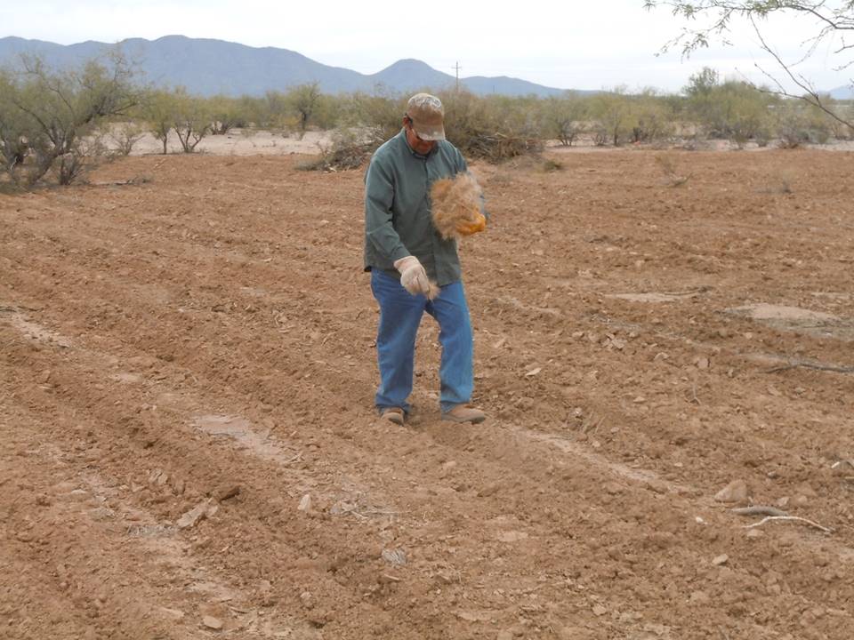
It is not uncommon for grazing land mechanical treatment and several of the other practices described so far to be used in combination to restore the health of an area of rangeland. The following photo series provides an example of this – an area is treated first with Brush Management, then with Grazing Land Mechanical Treatment followed by Range Planting. The final photo (Figure 7-31) shows the resulting range condition post treatment.
Heavy Use Area Protection – 561
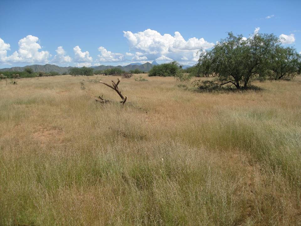
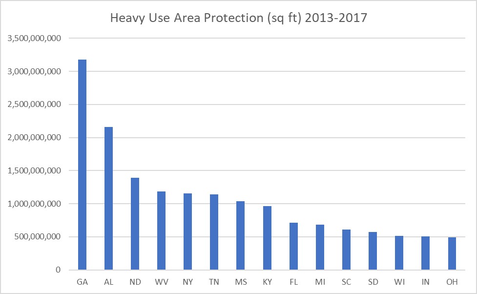
Areas of heavy use by animals or humans may need extra protection so as not to become a source of dust. The NRCS defines Heavy Use Area Protection (561) as the stabilization of areas frequently and intensively used by animals, people, or vehicles by establishing vegetative cover, surfacing with suitable materials, and/or installing needed structures.144 Livestock feeding and watering facilities, portable hay rings, mineral boxes, and areas of frequent vehicular traffic are some examples of potential problem areas which may become denuded of vegetation over time and thus prone to wind erosion.145 Where possible, land managers should consider adjusting management practices to keep the extent of such areas to a minimum.144,145 In small areas of unavoidable heavy use, however, it may be desirable to pave or otherwise install a stable, non-eroding surface to protect water and air quality.
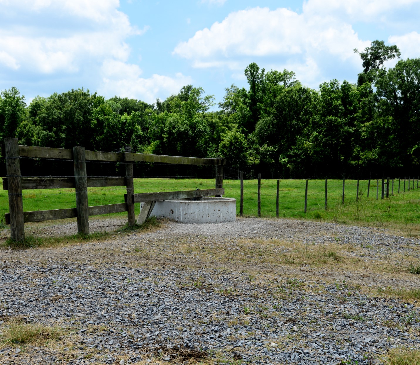
The best design and type of protective surface to install in a heavy use area will depend on site characteristics and the intended use. The local NRCS CPS (found in the local FOTG) for this practice can offer some general guidance on site preparation and design requirements for various construction materials and in most cases directs users to the appropriate section(s) of applicable engineering documents as well. Commonly used materials for Heavy Use Area Protection include concrete, bituminous concrete, and gravel; other materials such as soil cement, agricultural lime, roller-compacted concrete, and coal combustion by-products (flue gas desulphurization sludge and fly ash), may also be used where appropriate.146 Artificial mulches, such as cinders, bark mulch, brick chips, or shredded rubber can be used in some situations, but they are not recommended for livestock or vehicular applications.146 Sometimes a heavy use area can be stabilized by establishing vegetation of a species that can withstand the wear and tear it will receive.146 Land managers should establish vegetation in accordance with CPS Critical Area Planting and may also need to plan for periods of rest and recovery and/or use reinforcing materials such as geogrids.146
Safety of the users should always be a consideration when installing any surface or structure.146 For example, concrete surfaces may need roughening to avoid creating slippery conditions when wet.147 Likewise, sharp corners should be avoided, and materials used around livestock should not be of a type or shape that will cause hoof injury or other harm.146 Practicality is also important; if the area will be cleaned of manure by scraping, then a surface consisting of loose aggregates may not be a good choice.145 Prior to disturbing the ground for construction of the stable surface, always ensure that no buried utilities or other subsurface structures will be damaged by the activity.
Since reducing the permeability of an area will have an impact on water infiltration and runoff, consideration should be given as to how installing the planned Heavy Use Area Protection will impact the surrounding area in terms of water budget, erosion, and water quality.144 Provisions for handling runoff without contributing to erosion or water quality impairment should be included in the design.144 If the current location of a heavy use area poses a risk to nearby surface waters, the area may need to be relocated.145 Windbreaks or Shelterbelts (380) and Herbaceous Wind Barriers (603) can also help to minimize dust emission from a heavy use area.146 Access Control or Fence (382) can also be used to modify traffic patterns around the area.148 Sometimes it is appropriate to install a roof in a heavy use area, and in that case, users should refer to CPS Roofs and Covers (367).146 Some reports obtainable from Web Soil Survey that relate to Heavy Use Area Protection are listed in the help sheet found in Appendix B, Exhibit 7-1.
Prescribed Burning – 338
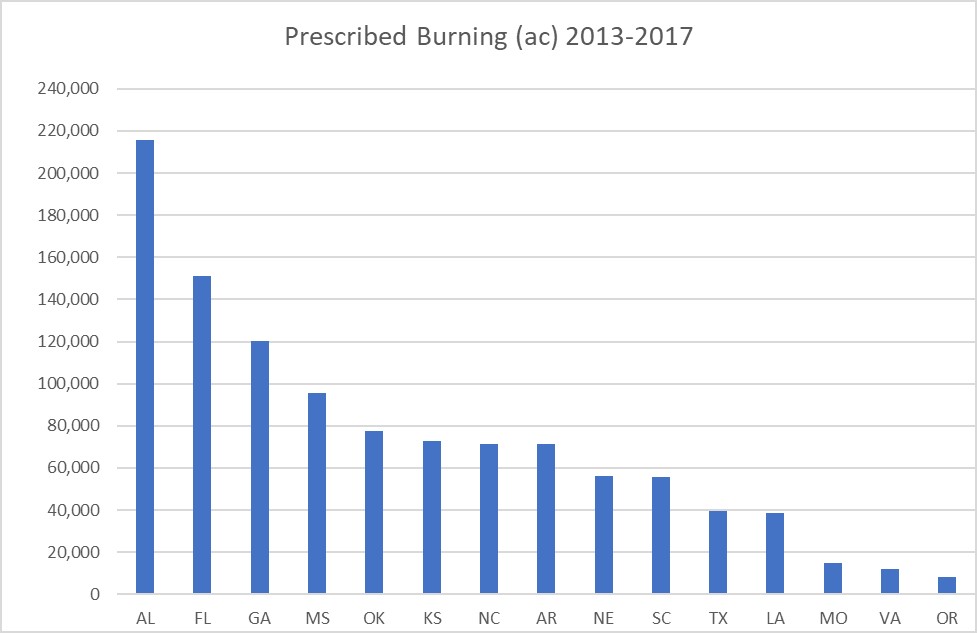
The NRCS defines Prescribed Burning (338) as “controlled fire applied to a predetermined area.” Prescribed Burning applies on rangeland, forestland, native pasture, pastureland, wildlife land, hayland, and other lands as appropriate.149
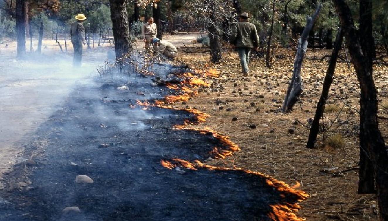
Prescribed burning does not in itself reduce wind erosion – in fact, it often makes the burned area more prone to erosion and may necessitate implementation of erosion-control measures as a follow-up.151 When used in concert with other appropriate practices, however, prescribed burning can be an effective tool to help achieve management goals. Prescribed burning may be used as a means of removing undesirable plants as part of Brush Management or Herbaceous Weed Treatment.97,98 Prescribed burning can also be used to remove accumulated dead residue and brush on previously abandoned pastureland which is to be brought back into forage production.152 Warm season grasses are more tolerant to burning than cool-season grasses, and it is generally not recommended to burn cool-season grasses unless the goal is to eradicate them.152 Follow up treatment to prescribed burning may include conservation practices such as Range Planting, Critical Area Planting, and/or Prescribed Grazing.151,153
Prior to burning, a burn plan needs to be developed and the landowner must secure all necessary permits;149 the landowner is responsible for complying with all applicable Federal, state, and local laws, rules and regulations when planning and during application of prescribed burning. Caution should be used in an area where burning may provide the opportunity for one or more undesirable plant species, such as an invasive annual grass, to take over the site post-disturbance. The anticipated response of noxious or invasive species should be addressed in the burn plan.154 The impact to cultural resources, threatened and endangered species, and use by local wildlife and pollinators should also be considered.150,155 Some wildlife-related information, such as ecological site information and location of wetlands can be found in Web Soil Survey, and a help sheet on how to find these reports is included in Appendix B, Exhibit 7-1.
Smoke management is an important component in planning and executing a prescribed burn.149,156,157 The National Wildfire Coordinating Group (NWCG) has published a Smoke Management Guide for Prescribed Fire158 which some may find helpful. The timing and burn intensity should be managed to minimize carbon released into the atmosphere.149 In some cases, smoke discharge from a controlled burn may be regulated by a state or local department of environmental control, from which approval must be obtained.154
The exact site conditions needed for a successful controlled burn are extremely specific and will be addressed in formulating the burn plan before any burn is implemented, however, in general weather and atmospheric conditions, fuel load, and purpose of the burn are all considerations. Additionally, the type and timing of a fire to control one species of woody brush may not be the same as the control of another undesirable plant.157,159 The best resource for site- and species-specific advice will be the expertise of local professionals consulted in the process of selecting Prescribed Burning as an appropriate treatment and preparing the burn plan. Beyond the physical potential of a site to support and benefit from a prescribed burn, however, there are some other equally important components that influence the practicability of conducting a prescribed burn:
Qualified personnel: Only those who have been properly trained and have the appropriate job approval authority and/or certification level may provide assistance in planning and implementing a prescribed burn.160 In parts of the country where fire is routinely used as a land management technique, there may be local appropriately qualified staff. In other areas where the application is less common, the required technical capacity may be a thinly stretched resource.100 Prescribed Burning can, however, be implemented using a burn plan that has been prepared at the landowner’s request by a qualified individual from another agency, provided the requirements for the CPS are still met.100
Land ownership and jurisdiction: For some, a pasture or range to be burned crosses jurisdictional boundaries. Examples of this would be managers who lease their land from several entities (e.g., State Trust, BLM, USFS) that hold adjoining parcels arrayed in a checkerboard pattern.100 All parties that hold any portion of the land to be burned must agree to the burn before it can happen, which adds another level of coordination to the effort.100
Liability: In the event that inadequate smoke management or an out of control/escaped fire results in damage to structures or property, harm to human health or safety, wildfire ignition, or any other harm, the landowner or cooperator may be liable for the damage.157,159,161 This may include the cost of fire suppression for an escaped fire.159,161 Some landowners carry an insurance policy that covers unintended mishaps associated with a prescribed burn, while others may have no such policy and may be understandably reluctant to take such a large risk.100 It is important that the landowner or cooperator fully understand their liability before making plans for a controlled burn.
Coordination with local entities: Local fire departments, public safety officials, and adjoining landowners need to be notified of the planned burn.149 It is often necessary to inform residents in the area as well to prevent a nuisance amount of unnecessary reports of the fire to local authorities/emergency personnel.100 There must be enough fire suppression equipment and personnel available during the burn to adequately respond to the fire’s behavior and prevent a wildfire or other safety, health, or liability incident.149 How much is “enough” depends on a variety of factors including weather conditions, fuel condition and moisture content, and other related effects such as possible obstruction to human or vehicular traffic due to heat or smoke. 156,157,159
Proximity to urban features: Presence of urban structures nearby can be hazardous should the burn get out of control. There may be a stipulated setback distance of several miles from urban boundaries or subdivisions that must be observed.154 Near populated areas there is also often a higher likelihood of encountering utilities conveyance structures such as power lines and natural gas pipelines, which need to be avoided. The hazard to vehicular traffic visibility and access may be a problem as well.149,157 An area that is situated relatively far from most urban features is generally a better candidate for prescribed burning.
The relative ease or difficulty in addressing the necessary components will influence the decision regarding whether or not to apply prescribed burning as a management tool. The extent to which NRCS can participate in the planning and execution of a prescribed burn also varies by state. In many states, policy stipulates that NRCS personnel cannot serve as fire boss and/or cannot ignite or assist with igniting a fire. In some places NRCS personnel cannot in any way participate in a burn implementation plan.151 There may also be restrictions in place regarding authorship of the burn plan. It is best to check with the local NRCS office to determine the type of assistance they can offer and if other resources are available if needed.
Prescribed Grazing – 528
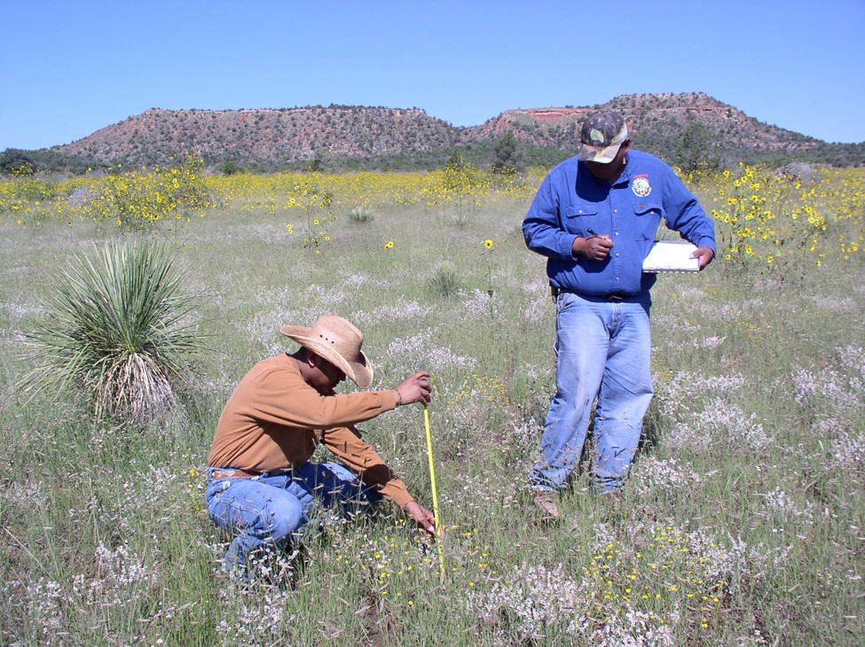
The NRCS definition for Prescribed Grazing (528) is managing the harvest of vegetation with grazing and/or browsing animals with the intent to achieve specific ecological, economic, and management objectives. Another common name for this practice is a grazing management plan. Managing the harvest of vegetation includes adjusting grazing animal numbers (accounting for grazing/browsing wildlife), adjusting the timing of grazing exposure to each pasture, and devising a rotational scheme of moving the livestock from pasture to pasture. A successful grazing plan is dependent on knowing the current condition and the production potential of the ecological sites on the ranch. There are numerous tools available for grazing land professionals and practitioners to utilize in gauging the condition of grazing lands: Range Health Assessment,162 Pasture Condition Score,163 and many range and pasture inventory and monitoring tools detailed in the National Range and Pasture Handbook.104
The practice standard recognizes numerous purposes for implementation:
• Improve or maintain desired species composition, structure and/or vigor of plant communities.
• Improve or maintain quantity and/or quality of forage for grazing and browsing animals’ health and productivity.
• Improve or maintain surface and/or subsurface water quality and/or quantity.
• Improve or maintain riparian and/or watershed function.
• Reduce soil erosion, and maintain or improve soil health.
• Improve or maintain the quantity, quality, or connectivity of food and/or cover available for wildlife.
• Manage fine fuel loads to achieve desired conditions
Although any of these purposes can validate the implementation of this practice in NRCS financial assistance program, a good Prescribed Grazing Plan will likely address and ameliorate multiple concerns listed above. The goal of Prescribed Grazing is to sustain productive grazing lands considering the economic viability of the ranching enterprise while balancing the needs of a diverse biotic community and a healthy watershed. Maintaining appropriate and acceptable vegetative cover is critical to controlling wind and water erosion on all forms of dryland grazing lands. This is accomplished with a rotational grazing plan based on a proper inventory of the soils, ecological sites, and forage resources across the entire ranch. The rotational grazing plan may utilize a rest-rotation schedule, where the “rest” cycle is a full-year non-grazing period for each pasture that is rotated annually. Or, the rotational grazing plan might consist of a deferred-rotation schedule, where each pasture is “deferred” from grazing typically during the growing season and the deferral is rotated annually from pasture to pasture. Or lastly, the rotation may consist of a high intensity-short duration schedule (sometimes called mob grazing), where the grazing pattern mimics the nomadic nature of wild grazing animals and the grasses are heavily grazed for a short period but then given ample time to recover. It should also be noted that deferment, apart from being a routine component of a deferred-rotation grazing plan, is a common consideration after a planned vegetative/soil manipulation on range, a range planting, prescribed fire, wildfire, or drought, to allow targeted grasses to develop good root structure and to mature to seed and promote a healthy seed bank in the soil.
Inventorying the forage resources and developing a short and long-term monitoring plan are required components of the Prescribed Grazing standard. Long-term monitoring plans are typically developed to support a goal of improving or maintaining species composition in a sensitive area, or on a specific ecological site(s), or a degraded pasture, or across the whole ranch. A short-term monitoring plan is used to assess effects of grazing, weather events, wildfire, and past land/vegetative treatments to make adjustments to the prescribed grazing plan as needed to protect the resource base. A proper inventory will identify unused, underutilized, and overutilized portions of the pastures or range. This, in turn, helps identify the needs for additional facilitative practices, such as fences, water developments, and soil/vegetative manipulations.
Many facilitative practices do show a benefit in addressing wind erosion according to the Conservation Practice Physical Effects (CPPE). However, this is due to the practice’s contribution to the improved distribution of livestock over the grazing unit. For instance, a Water Well (442) does not in itself control erosion on grazing lands, but it does help facilitate improved livestock distribution and more uniform forage utilization. Improved livestock distribution over the whole range reduces areas of degraded range.
Another important requirement of the Prescribed Grazing standard is the development of a drought management plan for the ranch. Drought is commonly described as when annual precipitation drops below 75% of the long-term (normally 30-year) average. During drought, good range managers understand grazing is not business as usual. Adjustments must be made to the grazing plan, including intensity, frequency, timing, duration, and distribution of grazing, and depending on the duration and severity of the drought, these adjustments must be continued for at least a year after the drought has broken. Thresholds must be set that trigger herd movement, pasture rest, supplemental feeding, and even herd culling. For instance, the grazing standard of “take half, leave half” might be adjusted to take 40%, leave 60% to reduce degradation of the plants’ root systems, and consequently the range in general. Guidance for drought management plans will vary from state to state due to the vast differences in landscapes and grazing systems. Some states have developed formats for drought management plans and incorporated them into the specification for the practice, such as North Dakota.164 Many land grant universities have assembled excellent guidance for managing grazing during drought, such as the University of Arizona Cooperative Extension’s publication Rangeland Management Before, During and After Drought,165 by Larry D. Howery, and USDA RMA/University of Nebraska/National Drought Mitigation Center partnered publication Managing Drought Risk on the Ranch - A Planning Guide for Great Plains Ranchers.166
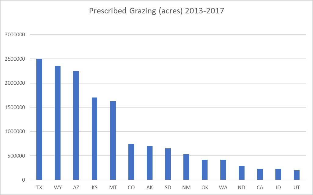
NRCS Environmental Quality Incentives Program (EQIP) payment schedules have practice scenarios based on the level of intensity of the grazing management plan, the complexity of the monitoring plan, wildlife management considerations, and identified needs for deferment. Prescribed Grazing is practiced in every state and territory; Figure 7-36 displays the top 15 states in implementing the practice.
Restoration of Rare or Declining Natural Communities – 643
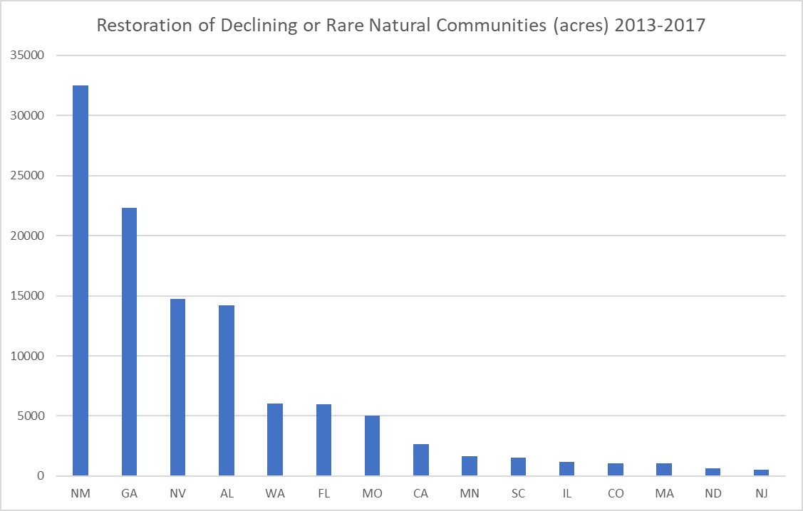
Restoration of Rare or Declining Natural Communities (643) applies where the goal is to restore, conserve, and/or manage unique or diminishing native terrestrial and aquatic ecosystems to return them to their original or usable and functioning condition.167 It can also apply to restoring a habitat of local cultural importance.167
Rejuvenating or restoring a rare or declining natural community on a site that has become degraded will almost always involve creating a plan that includes applying one or more other conservation practices, many of which are discussed elsewhere in this manual, such as Brush Management, Herbaceous Weed Treatment, Prescribed Burning, Range Planting, and so on.168 Whenever one of these practices is applied, the standards and specifications for that practice will also apply. For this reason, it is difficult to discuss Restoration of Rare or Declining Natural Communities separately, as it more a case of applying other conservation practices with the specific end-goal of restoring and managing a habitat of special concern.168
This practice can be applied in many settings and does not only apply to dust-prone areas,167 however when the plan includes improving the health of the vegetative community in an area that is susceptible to wind erosion, it will typically help decrease dust emission from that site through improved ground cover and increased root mass. Sometimes an area is taken out of commercial crop production to restore permanent vegetation associated with a rare or declining natural area.169 Where this is the case, this practice positively impacts air quality in two ways: reduced erosion potential due to more stable soil surface conditions, and often reduced CO2 emissions that are normally associated with crop production energy inputs.170
The biological communities eligible for this practice vary by state, and recommended procedures for restoration are quite specific to habitat type and location. The local FOTG should be consulted for practice details pertinent to the area of concern. Developing an appropriate restoration plan may involve consulting with other agencies and organizations that have expertise in conserving the target ecosystem, and with cultural specialists when species or habitats of local cultural importance are involved.167,171,172 Appropriate target conditions should be determined using reference sites, ecological site descriptions, or other appropriate references.167
Silvopasture Establishment – 381
Silvopasture is a management strategy whereby an operator can harvest multiple products from the same unit of land. It involves managing trees for high-value timber in a configuration and spacing that also leaves enough open canopy space to allow for the production of forage on the same plot.173 Usually, the forage is grazed by livestock, which can provide a source of income in the short-term to the operator while the trees are maturing.173 Shrubs may be included in the vegetation as well where compatible and desired,174 such as for browse. The land manager may also in some cases opt to manage the forage or browse component to benefit wildlife, rather than grazing domestic livestock.175
Establishing silvopasture can help reduce wind erosion in several ways. Stands of trees and shrubs can reduce wind-driven sediment transport by intercepting airborne particulates. Trees can also reduce wind velocity by as much as 70 percent, while the ground cover provided by perennial forage helps to further protect the soil surface from erosion176 and intercepts saltating particles.177
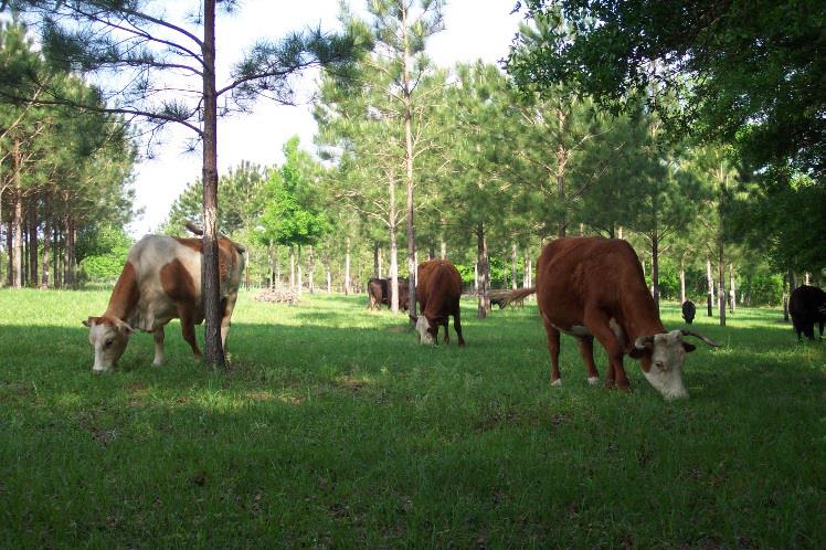
Silvopasture is typically established by either planting trees into an area being used for forage production, or by thinning a forested area enough to let sunlight adequate for forage establishment and growth penetrate to the understory,176,178 however trees and forage can also be established simultaneously.174 Trees in silvopasture systems are often planted or left in rows with alleys of forage in between, but may also take other configurations, as appropriate to the site and operational goals.176,178 Supplemental water may be needed to ensure establishment in some cases.174 The thriving requirements of forage plants used should be compatible with the shade/sunlight conditions that will be present due to tree canopy.176
A good silvopasture operation requires intensive management and may have significant startup costs due to installation of fencing and watering facilities, establishment or removal of trees, and forage establishment where needed.176 Maturing trees require pruning to produce high quality knot-free logs, and must also usually be thinned on a 5-7 year interval to maintain enough open canopy for forage production.176 Grazing is usually rotational and must be carefully monitored to avoid damage to both trees and forage from overgrazing.176 Tree seedlings and saplings are often vulnerable to damage from livestock and usually must be protected in some way, or alternately the pasture should be hayed rather than grazed, until the juvenile trees have reached a less vulnerable height and maturity stage.176 Despite being somewhat labor intensive, silvopasture has many environmental and practical benefits.176 Some key benefits and considerations are highlighted in the brochure “Working Trees: Silvopasture, An Agroforestry Practice”176 published by the USDA National Agroforestry Center (NAC). Silvopasture also increases carbon capture and storage.178
Appropriate tree and forage species and the best management techniques for successful silvopasture establishment and operation naturally have some variation from region to region. For this reason, it is important to seek guidance from local experts before beginning a project. Additional information on silvopasture is available from the USDA NAC179 and from local NRCS offices and the FOTG. The local Cooperative Extension may also have helpful resources or personnel who can offer assistance. See Appendix B, Exhibit 7-1 for how to find soil reports in Web Soil Survey that may also be helpful in planning a silvopasture operation.
Silvopasture is not a widely used practice across the nation and no nationwide statistics for this practice were available to the authors at the time of creating this handbook.
Watering Facility – 614, Water Well – 642, Water Harvesting Catchment - 636
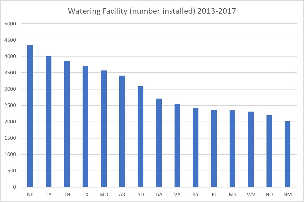
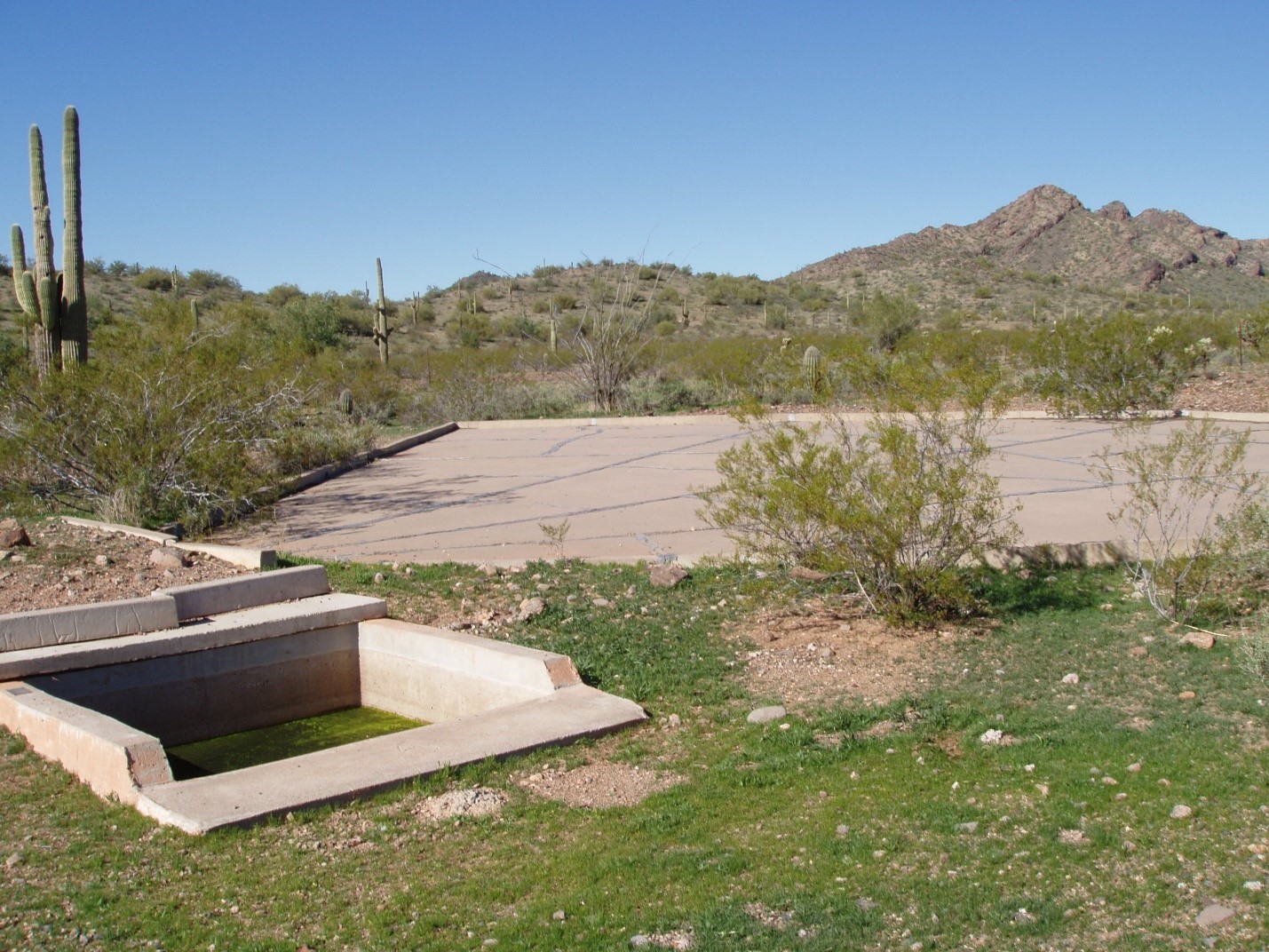
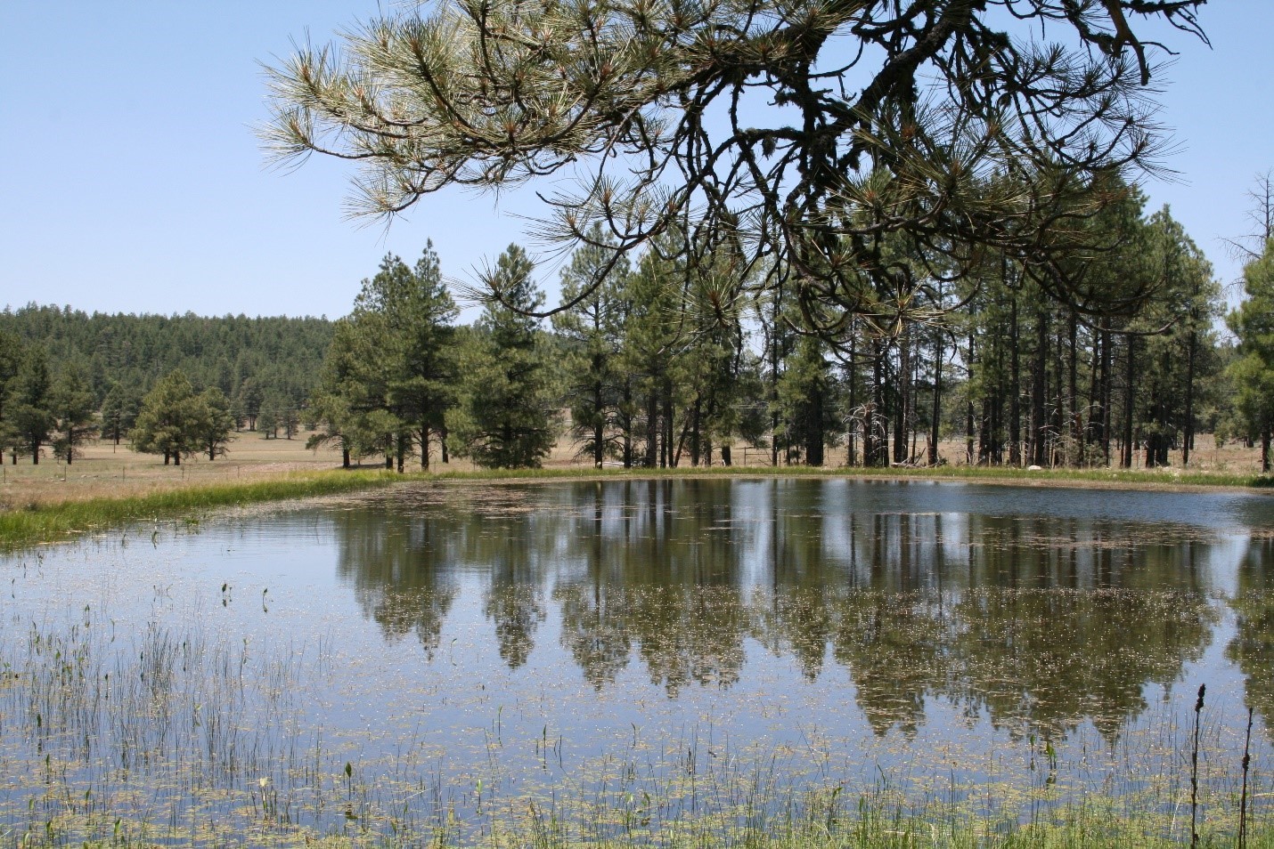
As stated previously, a watering facility does not in itself address wind erosion, but it does aid in the distribution of livestock over the grazed area for more uniform forage utilization. All watering facilities, by nature of trampling and grazing of congregated cattle, will result in small “sacrifice areas” around the water development where virtually no vegetation will grow. Conservation planners must be cognizant of this fact and locate these facilities where these impacts will be minimized, avoiding steep slopes and sandy soils that will be prone to erosion with no vegetated cover. Heavy Use Area Protection should be considered in the area immediately surrounding the watering facility, whereby gravel, concrete, geotextiles, and various mulching materials can be used to help keep soil in place.
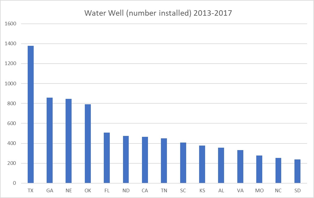
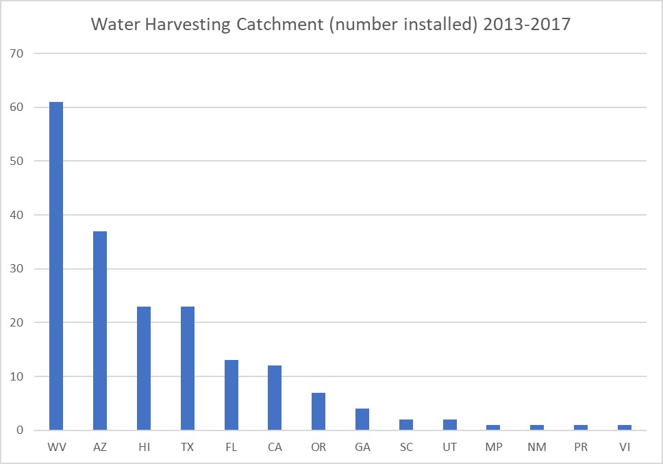
Across the arid West where ranches are very large and water sources scant, it often becomes necessary to drill wells in suitable areas to obtain the desired livestock distribution. The Water Well (642) practice standard is used in these instances. Where water wells are not feasible or too costly, an alternative is the Water Harvesting Catchment (636). Both practices typically include tanks for water storage, pipelines for conveyance and distribution, fence for protection of facilities, and water troughs. Water wells will also require some form of water pump, whether it be electric, solar, or windmill.
Spacing of water developments is critical in getting proper livestock distribution and forage utilization across all pastures. Recommended spacing varies widely across the country based on climate, forage availability, grazing system used, livestock type and breed, and wildlife pressure. Recommended spacing can be expressed in number of watering facilities per unit of area, for instance on pastureland- one watering facility per 10 acres. Or, it can be expressed in travel distance, for instance on Southwest rangeland- livestock should not travel more than one mile between forage and water. In rough country, spacing is typically half of what would be normal for that general area. Incorrect spacing can result in overly large sacrifice areas around watering facilities that expose the soil to wind and water erosion. Consult the local NRCS Field Office, Cooperative Extension, or land grant university for recommendations specific to the area of application. Some reports available from Web Soil Survey can also be of use, and a help sheet on how to find them is included in Appendix B, Exhibit 7-1.
References
32. Web Soil Survey. https://websoilsurvey.sc.egov.usda.gov/App/HomePage.htm.
79. USDA Natural Resources Conservation Service. Conservation Practice Standard – Access Control, Code 472. October 2017.
80. USDA Natural Resources Conservation Service, Oklahoma. Access Control – Oklahoma Conservation Practice Job Sheet 472 01. November 2011.
81. USDA Natural Resources Conservation Service, New Mexico. Access Control – 472, Conservation Practice Specifications/Job Sheet (New Mexico). October 2008.
82. USDA Natural Resources Conservation Service. Conservation Practice Standard – Access Control, Code 472 (Kansas). December 2011.
83. USDA Natural Resources Conservation Service. Conservation Practice Standard – Access Control, Code 472 (Iowa). February 2011.
84. USDA Natural Resources Conservation Service. Conservation Practice Standard – Access Control, Code 472 (Illinois). April 2015.
85. USDA Natural Resources Conservation Service. Conservation Practice Standard – Access Control, Code 472 (Oklahoma). November 2011.
86. USDA Natural Resources Conservation Service. Conservation Practice Standard – Anionic Polyacrylamide (PAM) Application, Code 450. September 2016.
87. USDA Natural Resources Conservation Service. Conservation Practice Standard – Anionic Polyacrylamide (PAM) Application, Code 450 (Florida). April 2017.
88. Virginia Department of, Environmental Quality. Erosion & Sediment Control Technical Bulletin #2 – Application of Anionic Polyacrylamide for Soil Stabilization and Stormwater Management. July 2002.
89. USDA Natural Resources Conservation Service. NRCS Conservation Practice Effects – Network Diagram: Anionic Polyacrylamide (PAM) Application, Code 450. September 2016.
90. Polyacrylamide (PAM). In: Storm Water Management BMP Handbook. South Carolina Department of Health and Environmental Control; 2005:41-42.
91. Wisconsin Department of Natural Resources. Land Application of Additives for Erosion Control (1050) – Conservation Practice Standard. December 2015.
92. Polyacrylamide (PAM) (v2010.2.12). In: Michigan Nonpoint Source Best Management Practices Manual. Rev 2017.6.27. Michigan Department of Environmental Quality Environmental Assistance Center.
93. USDA Natural Resources Conservation Service. Conservation Practice Specification – Anionic Polyacrylamide (PAM) Application, Code 450 (Colorado). September 2018.
94. USDA Natural Resources Conservation Service. Conservation Practice Standard – Anionic Polyacrylamide (PAM) Application, Code 450 (Idaho). March 2015.
95. Green VS, Stott DE. Polyacrylamide: A review of the use, effectiveness, and cost of a soil erosion control amendment. In: The 10th International Soil Conservation Organization Meeting. Purdue University and the USDA-ARS National Soil Erosion Research Laboratory; 1999:384-389.
96. USDA Natural Resources Conservation Service. NRCS Conservation Practice Specification - 450 - Anionic Polyacrylamide (PAM) Application (California). September 2017.
97. USDA Natural Resources Conservation Service. Conservation Practice Standard – Brush Management, Code 314. March 2017.
98. USDA Natural Resources Conservation Service. Conservation Practice Standard – Herbaceous Weed Treatment, Code 315. March 2017.
99. USDA Natural Resources Conservation Service. Wyoming Conservation Practice Specification – Brush Management, Code 314.
100. Smarik S. personal communication (6/4/2019). June 2019.
101. USDA Natural Resources Conservation Service. Conservation Practice Standard – Brush Management, Code 314 (New Mexico). May 2018.
102. USDA Natural Resources Conservation Service. Conservation Practice Specifications – Brush Management, Code 314 (Idaho). July 2010.
103. Ecological Site Descriptions | NRCS. https://www.nrcs.usda.gov/wps/portal/nrcs/main/national/technical/ecoscience/desc/. Accessed July 30, 2019.
104. Butler LD, Cropper JB, Johnson RH, et al. National Range and Pasture Handbook. Fort Worth, TX: United States Department of Agriculture Natural Resources Conservation Service, Grazing Lands Technology Institute; 2003. https://www.nrcs.usda.gov/wps/portal/nrcs/detail/national/landuse/rangepasture/?cid=stelprdb1043084.
105. Butler LD, Cropper JB, Johnson RH, et al. Chapter 8: Wildlife Management on Grazing Lands. In: National Range and Pasture Handbook. Fort Worth, TX: United States Department of Agriculture Natural Resources Conservation Service, Grazing Lands Technology Institute; 2003.
106. USDA Natural Resources Conservation Service. Conservation Practice Specification – Brush management, Code 314 (Texas). July 2017.
107. USDA Natural Resources Conservation Service. Brush Management Design Procedures (314DP)-1. February 2014.
108. USDA Natural Resources Conservation Service. Planning Brush Management in California, Technical Notes (TN-RANGE-CA-62). March 2018.
109. Pinyon Ips Beetle (Ips confusus) | Nevada Division of Forestry.
110. USDA Natural Resources Conservation Service. Conservation Practice Specification – Brush Management – Pinyon Pine and Juniper, Code 314A (Nevada). September 2015.
111. Factors Affecting Soil-Applied Herbicides | Field Crops. Cornell College of Agriculture and Life Sciences. https://fieldcrops.cals.cornell.edu/corn/weed-control-corn/factors-affecting-soil-applied-herbicides/. Accessed August 5, 2019.
112. Windows Pesticide Screening Tool – WIN-PST.
113. Targeted Grazing. https://www.webpages.uidaho.edu/rx-grazing/index.htm. Accessed July 31, 2019.
114. Launchbaugh K, ed. Targeted Grazing: A Natural Approach to Vegetation Management and Landscape Enhancement. American Sheep Industry Association; 2006. https://www.webpages.uidaho.edu/rx-grazing/index.htm. Accessed July 31, 2019.
115. Biological Control : A Guide to Natural Enemies in North America. https://biocontrol.entomology.cornell.edu/index.php. Accessed July 31, 2019.
116. USDA Natural Resources Conservation Service. Conservation Practice Standard – Critical Area Planting, Code 342. September 2016.
117. USDA Natural Resources Conservation Service. Critical Area Planting Conservation Practice Standard 342 Guidance (Florida). February 2018.
118. USDA Natural Resources Conservation Service. Conservation Practice Standard – Critical Area Planting, Code 342 (Idaho). February 2014.
119. USDA Natural Resources Conservation Service. Conservation Practice Standard – Critical Area Planting, Code 342 (Colorado). December 2016.
120. USDA Natural Resources Conservation Service. Critical Area Planting, Kentucky Practice Job Sheet 342. April 2014.
121. USDA Natural Resources Conservation Service. Conservation Practice Specification – Critical Area Planting, Code 342 (Montana). May 2017.
122. USDA Natural Resources Conservation Service. NRCS Planners Guide – Critical Area Planting, Code 342 (Washington). February 2017.
123. USDA Natural Resources Conservation Service. Conservation Practice Standard – Critical Area Planting, Code 342 (Arizona). September 2017.
124. USDA Natural Resources Conservation Service. Georgia NRCS Critical Area Planting Standard (Code 342) Appendix 1. Criteria Applied to all Purposes. October 2018.
125. USDA Natural Resources Conservation Service. Conservation Practice Standard – Dust Control on Unpaved Roads and Surfaces, Code 373 (Arizona). May 2012.
126. Bolander P, Yamada A. Dust Palliative Selection and Application Guide. San Dimas, California: United States Department of Agriculture Forest Service, Technology & Development Program; 1999.
127. U.S. Department of Transportation, Federal Highway Administration. Unpaved Road Dust Management, A Successful Practitioners Handbook. Publication No. FHWA-CFL/TD-13-001. U.S. Department of Transportation, Federal Highway Administration; 2013. https://www.fhwa.dot.gov/clas/pdfs/UnpavedRoadDustManagementASuccessfulPractitionersHandbook.pdf. Accessed September 10, 2019.
128. USDA Natural Resources Conservation Service. Conservation Practice Standard – Dust Control on Unpaved Roads and Surfaces, Code 373 (Colorado). November 2010.
129. USDA Natural Resources Conservation Service. Conservation Practice Specification – Dust Control on Unpaved Roads and Surfaces, Code 373 (California). November 2018.
130. USDA Natural Resources Conservation Service. Conservation Practice Standard Overview - Dust Control on Unpaved Roads and Surfaces, Code 373 (Utah). December 2012.
131. USDA Natural Resources Conservation Service. Conservation Practice Standard – Dust Control on Unpaved Roads and Surfaces, Code 373. May 2019.
132. USDA Natural Resources Conservation Service. Conservation Practice Standard – Forage and Biomass Planting, Code 512 (Illinois). April 2015.
133. USDA Natural Resources Conservation Service. NRCS Construction Specifications – Forage and Biomass Planting (Kansas). December 2016.
134. USDA Natural Resources Conservation Service. NRCS Specification Guide Sheet – Forage and Biomass Planting, Code 512 (Maine). March 2011.
135. USDA Natural Resources Conservation Service. Conservation Practice Standard – Forage and Biomass Planting, Code 512. January 2010.
136. USDA Natural Resources Conservation Service. Conservation Practice Specifications – Forage and Biomass Planting, Code 512 (Arkansas).
137. USDA Natural Resources Conservation Service. Conservation Practice Standard – Grazing Land Mechanical Treatment, Code 548. September 2010.
138. USDA Natural Resources Conservation Service. Conservation Practice General Specification – Code 548 (Texas). October 2014.
139. USDA Natural Resources Conservation Service. Oklahoma Conservation Practice Job Sheet 548 01 – Grazing Land Mechanical Treatment. September 2011.
140. USDA Natural Resources Conservation Service. Conservation Practice Specification – 548 – Grazing Land Mechanical Treatment (California). May 2012.
141. USDA Natural Resources Conservation Service. Conservation Practice Standard – Grazing Land Mechanical Treatment, Code 548 (Wyoming). December 2011.
142. USDA Natural Resources Conservation Service. Conservation Practice Standard – Grazing Land Mechanical Treatment, Code 548 (Oklahoma). September 2011.
143. USDA Natural Resources Conservation Service. Conservation Practice Standard – Grazing Land Mechanical Treatment, Code 548 (Arizona). August 2010.
144. USDA Natural Resources Conservation Service. Conservation Practice Standard – Heavy Use Area Protection, Code 561 (Idaho). July 2010.
145. USDA Natural Resources Conservation Service. Conservation Practice Standard – Heavy Use Area Protection, Code 561 (Florida). August 2017.
146. USDA Natural Resources Conservation Service. Conservation Practice Standard – Heavy Use Area Protection, Code 561. September 2014.
147. USDA Natural Resources Conservation Service. Conservation Practice Standard – Heavy Use Area Protection, Code 561 (Oklahoma). September 2015.
148. USDA Natural Resources Conservation Service. Conservation Practice Standard Overview – Heavy Use Area Protection, Code 561. September 2014.
149. USDA Natural Resources Conservation Service. Conservation Practice Standard – Prescribed Burning, Code 338. September 2010.
150. USDA Natural Resources Conservation Service. Conservation Practice Standard – Prescribed Burning, Code 338 (Arizona). May 2002.
151. USDA Natural Resources Conservation Service. Conservation Practice Standard – Prescribed Burning, Code 338 (California). November 2013.
152. Chapter 5, Section 2: Management of Grazing Lands – Managing Forage Crops and Pasture Lands. In: National Range and Pasture Handbook. Rev. 1. United States Department of Agriculture Natural Resources Conservation Service, Grazing Lands Technology Institute; 2003.
153. USDA Natural Resources Conservation Service. Conservation Practice Specification – Prescribed Burning, Code 338 (Nevada). January 2010.
154. USDA Natural Resources Conservation Service. Conservation Practice Specification – Prescribed Burning, Code 338 (Arizona). October 2003.
155. USDA Natural Resources Conservation Service. Conservation Practice General Specifications – Prescribed Burning, Code 338 (Texas). October 2014.
156. Deal P. National Range and Pasture Handbook, Supplement FL-2. February 2003.
157. USDA Natural Resources Conservation Service. NRCS Construction Specifications – Prescribed Burning (338) (Kansas). April 2019.
158. Peterson J, Lahm P, Fitch M, et al., eds. NWCG Smoke Management Guide for Prescribed Fire. National Wildfire Coordinating Group; 2018.
159. USDA Natural Resources Conservation Service. Conservation Practice Standard – Prescribed Burning, Code 338 (Wisconsin). March 2016.
160. Appendix A: NRCS Policy on Prescribed Burning on Grazing Lands. In: National Range and Pasture Handbook. United States Department of Agriculture Natural Resources Conservation Service; 1997.
161. USDA Natural Resources Conservation Service. Conservation Practice Standard – Prescribed Burning, Code 338 (Missouri). January 2005.
162. Pellant M, Shaver P, Pyke DA, Herrick JE. Interpreting Indicators of Rangeland Health, Version 4. Technical Reference 1734-6. Denver, Colorado: U.S. Department of the Interior, Bureau of Land Management, National Science and Technology Center; 2005.
163. Guide to Pasture Condition Scoring | NRCS.
164. Specification – 528 Appendix B, Prescribed Grazing Drought Management Contingency Plan. In: North Dakota FOTG Section IV - Conservation Practices. USDA Natural Resources Conservation Service, North Dakota; 2018.
165. Howery LD. Rangeland Management Before, During and After Drought. 2016. https://repository.arizona.edu/handle/10150/625546. Copy stored locally as allowed under the Creative Commons license that applies to this item, described as https://creativecommons.org/licenses/by-nc-sa/4.0/.
166. Managing Drought Risk on the Ranch – A Planning Guide for Great Plains Ranchers. Lincoln Nebraska: University of Nebraska – Lincoln, National Drought Mitigation Center https://drought.unl.edu/ranchplan.
167. USDA Natural Resources Conservation Service. Conservation Practice Standard – Restoration of Rare or Declining Natural Communities, Code 643. March 2017.
168. Smarik S. personal communication (7/10/2019). July 2019.
169. USDA Natural Resources Conservation Service. 643A Restorations of Rare or Declining Natural Communities, Pollinators, Conservation Practice Specification (CA). November 2017.
170. USDA Natural Resources Conservation Service. Conservation Practice Effects – Network Diagram: Restoration of Rare or Declining Natural Communities, Code 643. August 2017.
171. USDA Natural Resources Conservation Service. Conservation Practice Standard – Restoration and Management of Rare or Declining Habitats, Code 643 (Alabama). November 2012.
172. USDA Natural Resources Conservation Service. Conservation Practice Standard – Restoration and Management of Rare or Declining Habitats, Code 643 (Kentucky). July 2013.
173. USDA Natural Resources Conservation Service. Conservation Practice Standard Overview – Silvopasture Establishment, Code 381 (Arkansas). January 2015.
174. USDA Natural Resources Conservation Service. Conservation Practice Standard Overview – Silvopasture Establishment (381). May 2016.
175. USDA Natural Resources Conservation Service. Conservation Practice General Specification – Silvopasture Establishment, Code 381 (Arkansas). June 2017.
176. Working Trees: Silvopasture, An Agroforestry Practice. Work Trees USDA-NAC. June 2008. http://digitalcommons.unl.edu/workingtrees/10. Accessed July 3, 2019.
177. USDA Natural Resources Conservation Service. Conservation Practice Standard – Herbaceous Wind Barriers, Code 603. September 2015.
178. USDA Natural Resources Conservation Service. Conservation Practice Standard – Silvopasture Establishment, Code 381. May 2016.
179. U.S. Department of Agriculture National Agroforestry Center. Silvopasture. https://www.fs.usda.gov/nac/practices/silvopasture.php. Accessed July 31, 2019.
