
Adapted from the WEPS 1.5 User Manual17
WEPS is a process-based, daily time-step model that simulates weather, field conditions, and erosion. As such, it simulates not only the basic wind erosion processes, but also the field processes that modify a soil's susceptibility to wind erosion. It is designed to provide the user with a simple tool for inputting initial field conditions, calculating soil loss, and displaying either simple or detailed outputs for conservation planning and designing erosion control systems.
Research in the 1980’s provided the initial attempt to outline a processed based approach to simulating wind erosion that would replace the Wind Erosion Equation (WEQ). Following this initial work, the modular structure used in the current WEPS model was developed and the experimental research needed to support that structure was outlined. Numerous field and laboratory studies were conducted to develop relationships for surface conditions and erosion. Experimental data were collected for weather, hydrology, crop growth, residue decomposition, soil, management, and erosion. Experiments were conducted to validate that the erosion routines were producing accurate and precise erosion estimates.
A multi-disciplinary team assembled to develop WEPS included climate modelers, agronomists, agricultural engineers, soil scientists, and crop modelers. In 2005, WEPS was released to the NRCS for testing and further development for field office conservation planning. In 2008 WEPS was released to NRCS for field office implementation.
Early in the WEPS development process, input was requested from potential users on the needed capabilities of a new wind erosion simulation model. Based on these requirements, WEPS was designed to:
Provide more accurate and detailed estimates of soil loss by wind from agricultural fields. Results for WEQ were an annual average soil loss based essentially on average weather and field conditions. Since erosion is often the result of extreme weather events (e.g., high wind or dry soil conditions), an approach that accounts for such extreme conditions was needed to simulate the extreme soil loss for these situations. In addition, WEPS is capable of outputting erosion loss and surface conditions on a relatively fine temporal scale (e.g., hourly). However, for practical purposes, the default time step for WEPS output is two weeks. Such detail allows the user to observe the periods when excessive erosion occurs and the wind or surface conditions which caused the soil loss (e.g., low vegetative cover). These conditions can then be addressed by altering management or other control measures.
Develop more cost-effective erosion control methods. The detail in the soil loss and field conditions provided by WEPS is a valuable tool for testing various management scenarios or control methods through simulation. Each scenario can be evaluated before a change in farming practices is made in the field. Surface conditions and management can be observed during periods of excessive loss and adjusted to minimize erosion.
Simulate the amount of soil loss by direction. With increasing concern about the impacts of wind erosion on soil, water, and air quality, the capability of WEPS to provide the direction of soil loss is useful. For example, creep and saltation loss to a roadside ditch or waterway will impact water quality, so attention can be focused in these scenarios to control loss based upon impacts. Similarly, suspension loss in the direction of highly populated areas and control strategies can be simulated with WEPS.
Separate soil loss into creep/saltation, suspension, and PM10 components. Each of these components have specific characteristics and effects. Particles lost through creep/saltation are typically deposited locally where they can affect soil and water quality, bury crops, roads, and irrigation ditches, or be deposited as dunes in fences or windbreaks. Suspension particles, by definition, can be lifted into the air and carried great distances. As such, it can be a detriment to air quality, become a health hazard, and reduce visibility along transportation systems. PM10 has been determined by the U.S. Environmental Protection Agency to be a hazard to air quality and a respiratory hazard in particular.23 Estimating soil loss of each of these components can aid in environmental assessments.
Taking all user requirements into consideration, WEPS is designed to be an aid in: 1) soil conservation planning, 2) environmental assessment and planning; and 3) determining offsite impacts of wind erosion.
WEPS Modeling Approach
To simplify inputs, WEPS is designed with specific geometric constraints when specifying the simulation region or field (Figure 3-1). The simulation area may be rotated to orient the field correctly on the landscape to account for the effects of varying tillage, planting, and wind directions.
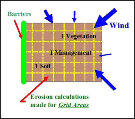
A uniform simulation region surface is assumed in that only one soil type (uniform soil properties), crop type (biomass properties), and management are uniformly distributed over the field. In reality, fields are often not uniform so the user may select the dominant-critical (i.e., most erodible) soil or crop condition for a simulation. Barriers may be placed on any or all field boundaries. When barriers are present, the wind speed is reduced in the sheltered area on both the upwind and downwind sides of the barriers.
The erosion submodel determines the threshold friction velocity at which erosion can begin for each surface condition. When wind speeds exceed the threshold, the submodel calculates the loss/deposition over a series of individual grid cells representing the field. The soil loss and deposition is divided into components of saltation/creep and suspension, because each has unique transport modes, as well as off-site impacts. The field surface is periodically updated during erosion events to simulate the surface changes caused by erosion. Surface updating during an erosion event includes changes to aggregate size distribution of the surface as fine particles are removed, smoothing of ridge roughness as ridges are eroded and furrows filled with eroded materials.
Once given user supplied inputs, the interface accesses five databases for climate, soils, management, barriers, and crop growth and residue decomposition for the simulation. These databases provide needed parameters for location and conditions simulated as specified by the user. WEPS also uses 50 years of climate data containing daily precipitation, maximum and minimum temperatures, solar radiation, and dew-point temperature as well as a daily wind direction and sub-daily (e.g., hourly) wind speeds.
These input files for a given simulation are collectively known in WEPS as a “run”. The science model reads the input run files and calls the Hydrology, Soil, Crop, and Decomposition submodels daily which account for changes in the soil surface erodibility as influenced by Management and Weather. If surface conditions for a given day are such that erosion can occur for the maximum wind speed for that day, Erosion submodel routines are called to calculate soil loss and deposition. Soil erosion by wind is initiated when the wind speed exceeds the saltation threshold speed for a given soil and biomass condition. After initiation, the duration and severity of an erosion event depend on the wind speeds and the evolution of the surface conditions.
Since WEPS uses 50 years of data to determine the average erosion rates, it is not useful for looking at the effects of single weather events. The SWEEP program (single wind erosion event program) can be used along with the WEPS erosion model to determine the soil losses from individual weather events. This program is not a formal part of the NRCS WEPS package, but is available from the USDA-ARS WEPS website.
References
17. Content largely adapted from: The Wind Erosion Prediction System: WEPS 1.5 User Manual. Fort Collins, Colorado, USA: USDA-ARS Rangeland Resources & Systems Research Unit; 2016. See original text for full citations.
23. U.S. EPA. National ambient air quality standards for particulate matter: Proposed decision. 40 CFR 50 61 (241). 1996.