
The majority of dust storms can be classified as convectively driven dust storms, synoptic scale dust storms, and dust channels. Dust storms can occur any time of the year and in some cases appear quickly and disappear quickly. They can be found in practically any location. The basic ingredients for dust storms are high winds exceeding the threshold for wind erosion and dry, erodible soil in the absence of vegetation cover. This section very briefly describes the meteorological drivers creating the winds for various types of commonly encountered dust storms.
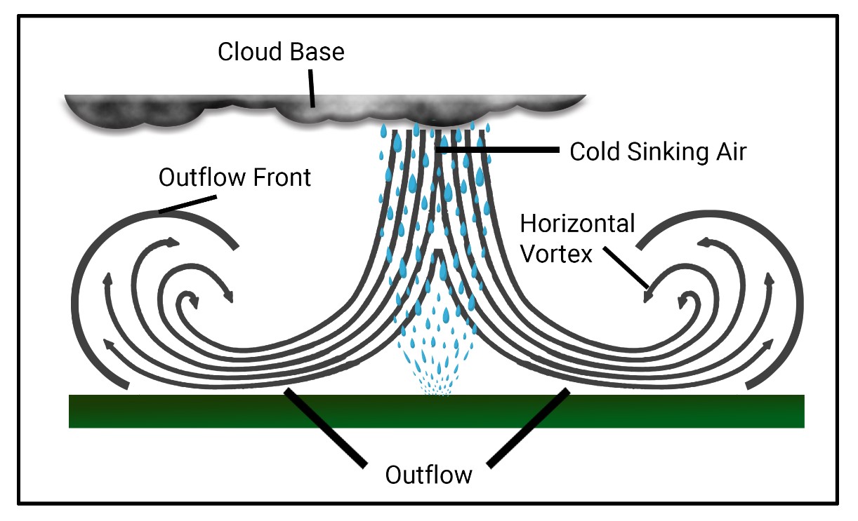
The first category are associated with thunderstorms. In the southwest convectively driven dust storms are common during the summer months when we see a seasonal shift in wind direction bringing in moist airmasses. During those times we often see surface dewpoint temperatures rise as shallow airmasses moves toward the region from the south and east. Storms starts out with convection over the higher terrain with smaller storm cells developing over the surrounding smaller mountain ranges. Convective storms grow in size and intensity, steered by upper level winds and pressure gradients. Once these storms reach maturity they then decay, losing energy through falling rain drops. If the lowest level of the atmosphere is dry, the drops eventually evaporate as they fall. Evaporation is a cooling process and as a result we observe cool downdrafts or air falling toward the ground. These descending winds eventually impact the surface and spread out horizontally. The horizontal winds can achieve speeds more than 70 mph over short distances over a time period of a few minutes. Very intense but localized winds include dry microbursts in scale of less than 5-kilometers across. In some cases impacts of evaporation are much larger as in the case of a large thunderstorm or a mesoscale convective complex extending over a hundred kilometers. Winds from these type of storms are called thunderstorm outflow winds and the leading edge of these are called outflow boundaries. In the desert Southwest these outflow boundaries can create dust storms that are often called haboobs. This particular type of dust storm is hazardous due to its quick formation, potential to create very high concentrations of aerosols, and extremely low visibility. Wind directions during these events can come from most any direction and depend on where the convection is located.
The second type of dust storm that occur are from midlatitude cyclones that bring in cold fronts and high winds over the region mainly in the spring. A smaller number of synoptic dust storms occur in the fall and winter. These high winds occur over a much longer period of time compared to the convectively driven ones. In some instances high winds over 30 mph with higher gusts are found in these storms covering more than 12 hours. These systems bring in strong winds from the southwest where winds occasionally reach 50 mph sustained. Winds of this type are straightforward to forecast and local National Weather Service offices provide several days of notice in these cases. Uncertainties in the forecasts of dust storms have been in the timing and location of the high winds, presence of precipitation during the storm, along with the condition of the soils. Synoptic dust storms occur frequently in the afternoon from 3 pm to 5 pm as higher winds aloft mix down toward the ground but can be found throughout the day. The longer duration storms from cold fronts tend to last much longer with some lasting an entire afternoon.
The third type are small in scale on the order of tens to hundreds of meters in size and are called dust channels. Dust channels arise by wind blowing across small erodible areas such as a recently disturbed parking lot, agricultural field or rangeland. Disturbance can be from many activities including building construction, off-road vehicles, and livestock. These type of dust events are particularly hazardous since they are highly localized, hard to predict, can change quickly in response to changes in wind direction and wind speeds. In many instances dust channels tend to be short in duration, less than 5 minutes, but can last longer depending on the meteorological cause of the winds. Another characteristic of these are the dust is often at very high concentrations low to the ground and degrades visibility to passenger vehicles but to lesser amounts for high profile trucks. Meteorological causes for dust channels can vary from thunderstorms to cold fronts.
Other meteorological conditions that are associated with high winds can be from downslope or Fohn winds such as the Santa Ana winds from the Mojave Desert impacting southern California. These winds can be amplified when they flow though valleys or narrow mountain passes. Other causes of dust include dust devils that can create low visibility conditions over small areas.